Rebuilding Place in the Urban Space

"A community’s physical form, rather than its land uses, is its most intrinsic and enduring characteristic." [Katz, EPA] This blog focuses on place and placemaking and all that makes it work--historic preservation, urban design, transportation, asset-based community development, arts & cultural development, commercial district revitalization, tourism & destination development, and quality of life advocacy--along with doses of civic engagement and good governance watchdogging.

Tuesday, November 18, 2025

DC District Bike Summit, 12/7/2025

The first annual.  

FWIW, I suggested something like this in 2010.  Montgomery County's Civic Federation, with the support of people in the planning department, did it if not in 2010, 2011 and 2012.  But I don't think it continued.

The MoCo meeting got some media coverage, at least with WTOP-radio, and by being co sponsored by the Civic Federation, it engaged older people in an area of interest often seen as dominated by younger demographics.

It's hardly an innovative suggestion.  Most state bike promotion groups have annual meetings.  

Eg it's been a long time, but I'd attended a couple of the meetings in Maryland, which are held in Annapolis, to facilitate interaction with state legislators and executive branch appointees.

Five years or so before 2010, I suggested an annual regionally-focused advocacy meeting on transit, moving from DC to Maryland and Virginia in succeeding years.

FWIW/2, DC has a bike promotion organization, Washington Area Bicyclist Association, while Chicago has a sustainable mobility organization--biking, walking, and transit--called the Active Transportation Alliance.

ATA grew out of the Chicago Bicycle Coalition.  NYC's Transportation Alternatives also addresses biking, walking, and transit.  

I think it makes more sense to have one organization addressing the three interconnected pro-environment modes.

I'm not sure about biking, but Montgomery County's Action Committee on Transit does address pedestrian issues too.

And rotating meetings across the jurisdictions.

Labels: , , ,

Saturday, December 09, 2023

Paris mayor plans to triple SUV parking tariffs to cut air pollution

-- "Paris mayor plans to triple SUV parking tariffs to cut air pollution"

From the article:

Paris will hold a referendum on 4 February asking residents to vote for or against a specific parking tariff for heavy, large and polluting SUVs. Earlier this year, Paris held a similar vote on whether to ban rented electric scooters and subsequently became the first European capital to ban them. 

If Paris votes yes on parking tariffs, the cost of on-street parking for an SUV or 4x4 car will rise to €18 (£15) an hour in the centre of Paris and €12 an hour in the rest of the city, officials said on Friday. The prices will apply to vehicles weighing more than 1.6 tonnes with a combustion engine or hybrid vehicles, and more than 2 tonnes for electric vehicles. The move will not apply to Paris residents’ parking.

... David Belliard, a deputy mayor of Pacoris for the Green party, said: “SUVs cost between €6,000 to €7,000 more than a standard car and all the studies by car firms show that they are bought by the wealthiest people with high incomes … This measure, if applied, will be directed at the richest people in order to finance the transformation of our public space to adapt to the climate crisis, so it’s a form of social redistribution.” 

He said if a person drove into Paris in an SUV and had to pay €36 for two hours’ parking, this would be an incentive to use another form of transport. “It is about sending a strong signal to those who drive these huge cars – or aspire to – that in the future it’s going to cost you more. We invite them to use other means of transport, there are alternatives.”

A Ford F-350 truck can be almost as wide as two DC rowhouses.

DC.  22 years ago, with the election of Anthony Williams as mayor of DC, there was a reinvigoration of the urban planning function in the city.  The first big initiative was to do "neighborhood plans" for each neighborhood area.  I don't remember the exact definition.  And my neighborhood was the first.

While lauded in planning circles, the initiative was pretty circumscribed, focused on directing how agencies spent their monies, but with no changes to how agencies budgeted and planned.

Anyway, someone, not me, suggested changing the residential parking permit system to charge more for larger vehicles.  Like SUVs.

It's still not done, although I think the car registration fee in DC does a form of this.

But not paid for parking (parking meters).

US car culture is complemented by a weak transit system.  It's hard to do something like this in the US, because our mobility system is centered around the car.  

For example, Paris has an amazing transit system which continues to expand ("Paris is getting a whole new Metro network. And it’s huge," CNN).  The amount of track miles that is being added to the existing system (800km) is just a bit smaller than the total track of the DC area Metrorail system, with 68 new stations being added, which is not quite 70% of the total number of existing Metrorail stations.

In most US cities, transit is an afterthought, an inefficient way to get around, and it is not constantly expanding and improving.

Labels: , ,

Saturday, March 18, 2023

Washington Cherry Blossom Festival and event transit

In the past, I've suggested as part of Presidential Inauguration Weekend, that transit on the Metrorail system and in DC should be free, if only as a throughput-transportation demand management measure.

-- "Should transit on Inauguration Day be free?," 2013/2016

Note that DC will be launching free surface transit later this summer ("Free ride: DC unveils bold plan to boost public transit," Associated Press), something I'll get around to writing about ("Is making surface transit free the best transit investment DC can make?," 2016).  So that makes a chief element of that idea realizable.

Photo by alphanumeric.

Seeing the Washington Post article "3 maps for getting to the 2023 Washington, D.C., Cherry Blossom Festival," about getting to the Cherry Blossom Festival, I had a similar thought.  

1. Besides improving public transit services on the National Mall generally.

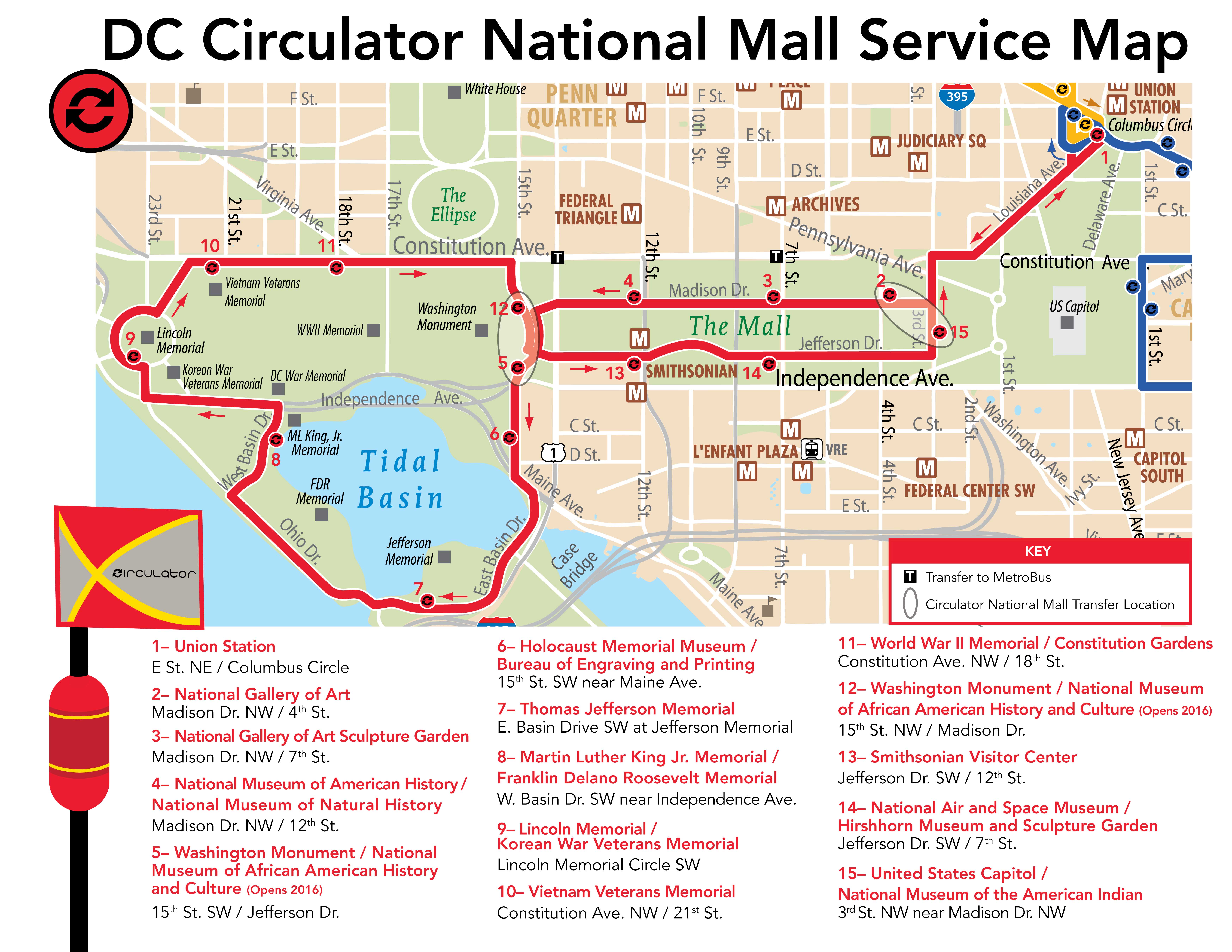
 --  "New DC Circulator route serving National Mall reminds us that we are neglecting connections from west to east and fail to adequately connect Georgetown to the National Mall," 2015
 -- "Revisiting: a proposal for heritage streetcar service on the National Mall | adding service to the DC waterfront"

2.  Why not improve transit on the National Mall specifically for the Cherry Blossom Festival, a highly important special event?  Note that back in the day Capital Transit provided weekend transit service to East Potomac Park.  And note that maybe the DC Circulator National Mall bus line is enough as it is (although it doesn't go to Georgetown).

3. Make it free.  Again, that's more out of simplicity than anything else.

--  "Transperth transit (Perth, Western Australia) provides free transit to certain events, like the Red Hot Chili Peppers concert on 2/12/2023," 2023

Labels: , , , , ,

Saturday, January 28, 2023

Some transit matters in Utah

1.  Poor transit to ski resorts in Salt Lake County.  During covid, the Utah Transit Authority had a hiring freeze, which now means that they don't have enough drivers and are cutting service as a result.  One of the services cut, partly because they don't have enough drivers with the experience to drive in serious snow and mountain/canyon conditions, is the UTA Ski Bus service, which serves Big and Little Cottonwood Canyons, home to four popular ski resorts.

So the County Tourism Office, Visit Salt Lake, has contracted with a private operator to provide additional service ("New ski shuttle to launch in Cottonwood canyons this week," Salt Lake Tribune).  It's $10 round trip, which seems reasonable.  Although equity based options should be made available too.  From the article:

The “Cottonwood Connect” ski shuttle will provide passengers $10 round-trip rides to either Alta and Snowbird in Little Cottonwood Canyon, or Brighton and Solitude in Big Cottonwood Canyon, on a first-come, first-serve basis beginning Thursday morning.

Service will run on Thursdays, Fridays, Saturdays and Sundays, as well as holidays, through April 16. Reservations must be made online in advance.

Riders can choose from 11 different locations for morning pickup — such as the Highland Park park-and-ride, or the Cottonwood Hyatt Place hotel. Then, they can select their ski resort destination, along with a time slot for return from the slopes.

A full list of stops and routes for the service are on the Visit Salt Lake website, here Cottonwood Connect.
But this should be a basic function of the local transit authority and it is damning that they can't pull it off.

2.  Especially since the Utah Department of Transportation's study of Little Cottonwood proposes gondola service.  I am fine with it.  But that doesn't mean that there aren't serious planning failures in the process.

-- Little Cottonwood Canyon EIS
-- The Gondola Works (website of proponents) 

A yard sign in the lot of an opponent to the gondola.

But they didn't propose it as part of an overall transportation demand management approach, and many quarters are opposed--which I don't really understand since gondolas are an exciting mode as part of a full range of transit options, especially in topographically challenged areas. 

Although legitimate criticism can be made that the process hasn't been conceptualized or handled very well.  

For example, it only proposes winter service, even though the Canyon is utilized just as much in the spring, summer and fall.  And there's talk that riding the gondola would cost $200 which is insane. 

3.  Recreation Transit District concept.  The failure to have a full TDM approach not just to Little Cottonwood Canyon but to Big Cottonwood and other outdoor recreation destinations, I have prepared an outline for the creation of what I call a "recreation transit district" in Salt Lake County to provide service to various recreational sites across the county.  FWIW, the Ski Bus service only runs in winter, while the canyons are used year round, and most recreational sites across the county aren't served by transit. 

From a transportation demand management and equity perspective, you shouldn't be required to have a car to be able to recreate.

I first wrote up the proposal in June, in response to a road project in Millcreek Canyon, and it uses a variety of recreational transit examples including Seattle, Colorado ("8 Ways to Get to the Mountains This Winter Without Driving Yourself," 5280), and Utah's own Park City, which has an extensive in city transit system serving all the ski resorts, and is free. And how Greater Seattle's Crystal Mountain Ski Resort has an extensive TDM program including free bus service ("Crystal Mountain is taking on parking woes with a shuttle. Our reporter took the bus to ski," Seattle Times).  But it needs an update.

But there are more opportunities to submit it, as there are two other ongoing studies, a transit study for Big Cottonwood Canyon, and the Tri-Canyons Trails Master Plan access study by the US Forest Service, which controls most of the lands in Big and Little Cottonwood Canyons and Millcreek Canyon.

Both have public comment and/or public meetings happening currently.

Photo taken on a bad air day in August 2021.

4.  Free transit proposal. In 2022, transit on UTA (train, light rail, streetcar, bus) was free in the month of February (Free Fare February Final Report, UTA).  Previously, there had been free days here and there, usually associated with days where air quality was particularly bad.

But free transit for entire month got people wanting it to be free all the time.  Apparently the Utah Legislature is considering a proposal to test this for one year, perhaps in the next fiscal year ("Free transit for a year has to get past the Utah Legislature first," KUER/NPR).

Interestingly, transit in Park City (Park City Transit) and Summit County (High Valley Transit) and Cache County/Logan, where Utah State University is, is run independent of UTA, which provides transit in the Salt Lake Valley in multiple counties, is already free.

5.  Free transit during the period around the NBA All Star Game.  I've written in the past about how for example, on Inauguration Day in DC, transit should be free ("Should transit on Inauguration Day be free?," 2013/2016), and how transit use is built into the ticketing process for some sports arenas ("Seattle Kraken expansion hockey team sets new standard for transit benefits in transportation demand management: free transit with ticket," 2019).  

For the period associated with the NBA All Star Game in Salt Lake, from February 12th to February 21st, UTA transit will be free, which is pretty cool ("UTA to have 10 zero-fare days for NBA All-Star game," ABC4).

6.  High Valley Transit steps up and takes over a bus route from Salt Lake to Park City that UTA severely truncated.  In another boneheaded move that sacrifices transit network breadth, the Utah Transit Authority changed the route of the SLC-PC Connect bus, Salt Lake City to Park City, eliminating all the stops in Salt Lake City, and re-routing it to a Park and Ride Lot in Millcreek, next to I-215, because of driver shortages ("In a major move, UTA to sharply cut back bus service in three counties, and it’s going to affect skiers," Salt Lake Tribune).  

As it was the bus started at the Salt Lake Central transit station, not the Airport, which meant it had minimal opportunity to capture transit trips from the Airport to Park City.

Shockingly, Summit County recognized this was not beneficial to them, and took over the route ("New commuter bus route from SLC to Park City rolls out this weekend," KPCW/NPR).  One problem is the original UTA bus service used the big inter city buses with plenty of room for luggage and bike racks on the front.  I'm not sure the HVT bus is the same, although I haven't taken it yet so I don't know for certain.

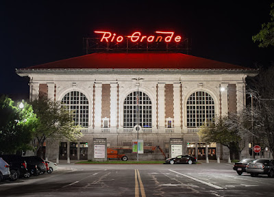
7.  Rio Grande Depot/Rail Undergrounding Proposal.  I went to a presentation a few days ago about a citizen plan to recenter train service on the historic Rio Grande Station.  

Flickr photo by Terry Redeker.

The railroad tracks were relocated a couple blocks behind the station around 2000. to a pretty gnarly set of platforms and a intermodal transit facility that doesn't have the grandeur or centrality of the rail station.

It's a pretty interesting idea, and would require relocating the railroad tracks underground and the light rail tracks closer.  It would repattern the land use significantly, allowing for significant build out opportunity of more than 50 acres.  

It could also refocus attention on transit as a legitimate mode, and recenter Salt Lake City's competitive advantages in part around transit.

-- Rio Grande Plan

I will be writing about this separately.

Flickr photo by Peter Ehrlich.

8.  Mayors initiative to extend passenger rail service to Boise and Las Vegas.  UTA has a decent commuter line, from Provo to Ogden, called the Frontrunner.  Ideally, it would be extended in both directions, to Southern Utah, and north to Logan.

Last year, the mayors of Salt Lake and Boise came together on an initiative to reconnect the cities by railroad ("A Utah train to Idaho? Salt Lake, Boise leaders are working to restore old service," KSL-TV; "Train corridors proposed connecting Boise, Las Vegas to Salt Lake City," Fox13).  Similarly, service could be extended to Las Vegas, where it could then connect to Los Angeles.

How they see the service being restored, although there should be a stub line to Logan, Utah, home to Utah State University.

In one way, it would merely restore services that once existed, service from Los Angeles to Salt Lake via Las Vegas, and service from Salt Lake to Idaho, Portland, and Washington.  Those trains were cancelled in 1999.

It should be pursued as a next step in the Rio Grande Plan.  And is basically along the lines of how I argue rail transit service should be organized in the US ("Two train/regional transit ideas: Part 1 | Amtrak should acquire Greyhound") modeled after Japan.

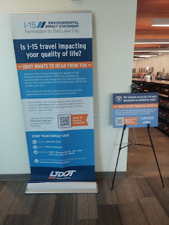
10.  Not transit per se, but the Utah Department of Transportation wants to widen I-15 through Salt Lake City ("UDOT unveils details on new $1.6B widening of I-15 through SLC," Building Salt Lake). 

-- UDOT releases transportation alternatives for I-15 from Farmington to Salt Lake City

 Given that Frontrunner parallels it, it's an impressive example of the failure to undertake multimodal corridor management.  As David Engwicht, the creator of the concept of transportation demand management realized, if you reduce the number of motor vehicles, you don't have to widen roads.

This piece has links to past entries concerning corridor management.

-- "Washington Post letter to the editor on repair-related closure of Rockville and Shady Grove Stations and corridor management" (2021)

Labels: , , , , , , ,

Thursday, December 29, 2022

Great way to visualize what I call the concepts of transit network breadth and depth: isochrones

One of my biggest learnings in transit planning is the necessity of separating planning from budgeting. 

I understand why this happens, but if there were true "mass transit planning," we would define the breadth and depth of the network that we want. And then come up with the funding to make it happen. 

 Transit operators would come back and say: you've defined the network's 

  • breadth: the area you serve and how you do it, with various modes) and 
  • depth: level/frequency of service)
as X. But the funding you're providing won't support that. 

Then there would have to be a discussion of how to address funding shortfalls in terms of raising revenues or cutting service.

Andy Larsen, the data-based beat (and also Utah Jazz) reporter for the Salt Lake Tribune, has a great article ("Need help deciding where to live? These maps can help") on the Utah Transit Authority's services, with some great graphics that with some tweaking illustrate the concepts of transit network breadth and depth.

They use the organizing principle of how far you can travel in 30 minutes, by car, bus, bike or train.  From the article:

Isochrones are maps that depict areas accessible from points within certain times using certain modes of travel.

Think about them as kind of reversing the questions asked in your typical Google Maps search. There, you want to figure out how many minutes it will take to get from point A to point B. Isochrones show you how many point B’s you can get to in so many minutes from point A. ...

In my exploration, probably the most user-friendly website where you can create your own isochrones is app.traveltime.com. Simply type in your starting point, choose how much time you have, and a preferred mode of transport. You can also layer different maps to compare and contrast. 


We've seen these kinds of graphics before, but I hadn't thought about it in terms of illustrating network breadth--where you can get to regardless of time, and depth--where you can get to quickly.


The point being that transit's "killer app" is being able to get somewhere reasonably quickly for not too much money.  

While both maps focus on what I call depth or frequency of service, the second map illustrates the point especially well, in terms of tranches of time.  

A basic network depth map would show the transit shed of all the areas served by the transit agency.  UTA is somewhat unusual in that it is the primary provider of transit in Salt Lake (Salt Lake City), Utah (Provo), Weber (Ogden), and Davis Counties, which are the primary population centers in the Salt Lake Valley region, as well as more rural counties.  (Logan--Cache County, and Summit County--Park City, provide transit service separately).

UTA, the Utah Transit Authority, provides light rail in Salt Lake County, railroad in Utah, Salt Lake, Davis, and Weber Counties, streetcar in Salt Lake City and South Salt Lake, and local, commuter, and rapid bus services.

The article includes a third map, comparing neighborhoods in terms of how much area can be reached without owning a car, but depending on sustainable modes.


FWIW, I think this map is a bit "misleading" because it only focuses on transit.  It doesn't take into account proximity of amenities, and perhaps most important in Salt Lake, topography.  The Avenues neighborhood has intense hills and the farther up you live, the steeper it is.  In fact, for biking, I've suggested that they get a version of the Trampe Bike Lift.

For example, I think that the Sugar House neighborhood now, and maybe Fairpark over the next 30 years, have the opportunity to be walkable communities as more intense multiunit housing is added, along with transit service.  Fairpark has light rail, and Sugar House has streetcar service, which is much more minimal.  But as density is added, there is retail, and at least in Sugar House, a tighter street grid can support walkability and cycling.  And best of all, both neighborhoods are flat.

Labels: , , , ,

More remonstration about the molasses of change: Transit planning, Baltimore County, Maryland and Towson

In the 1960s and early 1970s, the Urban Mass Transit Administration was funding "next generation subway" systems in the San Francisco Bay (BART), Atlanta (MARTA), Miami (Metrorail), Washington (WMATA), and Baltimore (Metro).

But Baltimore was late to the party, and instead of getting funding for all six of its planned lines, it got funding for one.  Note that Atlanta, BART, and Miami had problems of their own--certain suburban counties refused to participate for both Atlanta and BART, and Miami's route planners designed the system to serve areas they wanted to develop, rather than to ensure that service was also provided to key activity centers.

Comparing DC to Baltimore and the impact of transit made me realize how important to revitalization is a network of multiple lines serving residential and office districts and other activity centers, like airports, versus a single line.

For example at DC's core of 31 Metrorail stations, every one of those neighborhoods have improved reversing decades of decline.  Granted it took as much as 40-45 years to accomplish this.

Baltimore light rail in Downtown.  It's not sleek but has a kind of charm.  In my Purple Line writings, I've suggested as part of the contract, Maryland could upgrade to new cars on the Baltimore light rail.

Flickr photo by SoCal Metro.

Later, Maryland Governor Schaefer created a complementary light rail line, from a small industrial railroad that went bankrupt.  While serving Downtown Baltimore, the line wasn't that great from a transit network perspective, because it was built on a route that served industrial sites, not residential and commercial areas.  

In particular, it bypassed Towson, the county seat and the county's primary business district (unfortunately, the single subway line didn't go far enough east to serve the county's other primary business district, White Marsh).

In the interim the metropolitan planning organization proposed a secondary light rail line that would provide service directly to Towson, as well as to Columbia, Maryland, a primary activity center in Howard County.

Baltimore Regional Transit Expansion Map, 2002.

When I worked for Baltimore County in FY2010, as a bicycle and pedestrian planner, simultaneously the master plan update was going on, and I was asked to submit a briefing paper on transit and sustainable mobility.

The major point I made was that the transit lines needed to be knitted into a network and that the light rail needed to be rerouted to serve Towson directly and that the subway line needed to be extended to White Marsh.  

-- "From the files: transit planning in Baltimore," 2012, written originally in 2010

A secondary point was that the subway and light rail could be connected more directly in Baltimore City.  I didn't mention a southern extension to Columbia, because the memo was about Baltimore County, but that was implied.  

A few years later, a planner for MDOT made the point that the light rail should also be extended just one half mile to one mile north, to better serve the business district in Cockeysville where McCormick Spice is based.  Had I known that at the time, I would have suggested that too.

Now everything I wrote was rejected because it was at the peak of the post-2008 recession, and the planners were ordered to omit "any recommendations that cost money."

For what it's worth, over the past ten years, the regional recommendations for transit were incredibly paltry and stunted, in part because the Republican Governor, Larry Hogan, had negative interest in transit, except for maglev.

-- "Small update: Transit agenda for Greater Baltimore," 2021-

It appears that's changing.

Caption: see below 

There is an article a few months ago in the Baltimore Sun, "Maryland transportation officials ask for public comment on potential transit routes from Towson to Baltimore," that planners are suggesting that Towson be served directly by light rail.  From the article:

State transportation officials are asking for public input on seven proposed transit routes that would connect Towson to downtown Baltimore.

The Maryland Department of Transportation Maryland Transit Administration unveiled seven options for a new north-to-south transit line connecting Baltimore County to Baltimore City by light rail, bus or subway. The seven proposed “alternatives” were identified in a feasibility study completed in 2021. The assessment is one of the first out of 30 transit corridors the agency will study as part of its 25-year Regional Transit Plan aimed at improving public transportation in Central Maryland.

That could have been accomplished already. 

Especially if it had been prioritized in the 2010 Baltimore County Master Plan.

Building new infrastructure is hard enough, without politics and opposition interfering.

The Baltimore, Atlanta, Miami, and San Francisco examples have made me realize that it's almost impossible to do these projects "right" when major activity centers aren't included as part of the basic service program.

Caption from the Baltimore Sun.  Maryland Department of Transportation Maryland Transit Administration unveiled seven proposed transit lines from Towson to Baltimore in its “North-South Corridor Study,” an assessment completed in 2021 that’s one of the first of 30 corridor studies aimed at making public transportation more efficient in central Maryland. 

Alternative 1 (pink) Light Rail Transit from Lutherville to University of Maryland Medical Center (UMMC) via York Road/Greenmount Avenue. 

Alternative 2 (dark red) Bus Rapid Transit from Lutherville to University of Maryland Medical Center (UMMC) via York Road/Greenmount Avenue. 

Alternative 3 (purple) Bus Rapid Transit from Towson to Harbor East, via York Road/Greenmount Avenue. 

Alternative 4 (light green) Heavy Rail Transit (Subway) from Towson to Port Covington, via York Road/Greenmount Avenue. 

Alternative 5 (dark green) Bus Rapid Transit from Towson to Port Covington, via York Road/Greenmount Avenue. 

Alternative 6 (blue) Light Rail Transit from Lutherville to Otterbein, via Goucher Boulevard, Loch Raven Boulevard. 

Alternative 7 (oramge) Bus Rapid Transit from Towson to Harbor East, via Joppa Road, Loch Raven Boulevard.

Labels: , , , ,

Friday, October 14, 2022

Community Planning Month and transportation

Road Space Comparison comic by Randall Monroe, xkcd comics.

This comic is based on the first done in Germany performance of showing how much space different modes consume on the street.

-- October is National Community Planning Month

Books.  Two of the most important books related to transportation in terms of community planning are Reclaiming Our Cities and Towns: Better Living With Less Traffic by David Engwicht and Cities in Full by Steve Belmont.

Cities in Full is more technical, and now a bit out of date in its numbers, but it is great in putting numbers to the concepts laid out by Jane Jacobs in Death and Life of Great American Cities, including what kind of densities you need to make transit viable.

It lays out the argument for "recentralization" or at least densification, to be able to provide successful communities not dominated by the car.

It's an important book for both land use and transit.  Another key distinction laid out in the book is the difference between "monocentric" and "polycentric" transit systems.

Polycentric systems are spread out, and don't support the kind of intensification and ability to reduce car use in the way that more concentrated monocentric systems do.

He uses the MUNI system in San Francisco versus the BART system serving the Bay Area as contrasting examples.  He also discusses the Metrorail system in Greater Washington as an example of polycentricity.  (SF has about 900,000 residents in 47 square miles. It also has a "transit first" mobility policy as part of the City Charter, passed by referendum.)

But the one thing I figured out that he didn't is that unintentionally, at the core in DC, 31 stations function as a monocentric network within the polycentric network, in a manner comparable to how the MUNI system serves San Francisco.  

Arguably, the five Orange Line stations from Rosslyn to Ballston function monocentrically too, but as a straight line, not as a criss-cross network.

David Engwicht was an activist opposing the widening of a freeway in his community.  He figured out that if there were fewer car trips, roads didn't have to be widened.  This is the basis of the concept of "transportation demand management."  Reclaiming Our Cities and Towns: Better Living With Less Traffic, discusses TDM, humane communities, and mobility.  

He also discusses this in terms of "exchange."  Cities were created to facilitate exchange--all types, not just commerce--in efficient ways, and he diagrams how "too much" road space hinders exchange.

The book is very accessible, less technical than Cities in Full.

Book chapterThe transportation paper I reference the most in "Transportation and Urban Form: Stages in the Spatial Evolution of the American Metropolis" by geographer Peter Muller.  It's a chapter in a great textbook, The Geography of Urban Transportation, and I don't have a current edition.  I know the paper has been updated since I first read it 15 years ago.

It's key.  It discusses transportation in terms of the Walking City, Transit (Streetcar) City, Recreational Auto, and Metropolitan City eras and how transportation and land use have been organized in those periods.  The Walking and Transit Cities have pretty much the same urban form, denser, shorter distances between destinations, organized to facilitate movement on foot and then streetcar.  It also works well for bicycling.

The Metropolitan City is organized at the scale of the speed of automobile.  It is spread out over hundreds of square miles, with the deconcentration of land use and the separation of land use.  Transit tends to be an inefficient choice as the distances between major destinations is long.

(I collect ephemera--gas station maps, postcards, ads, magazine articles, illustrating mobility patterns from the different eras.)

Bicycling.  It's been a long time since I've read it, but I recall that Pedaling Revolution: How Cyclists are changing American cities is very good on bicycling for transportation.

Transit First Policy, San Francisco. The City of San Francisco adopted a "transit first" development policy in 1973. For the most part this means that new development in the downtown core has been built without parking, but with access to efficient transit.

For the most part, US transportation policy says that sustainable mobility is a good thing to do, everything in practice and funding prioritizes automobility, and makes sustainable mode support optional, not required.

That's why the SF policy is so novel.

Transit (and bicycling) opposition.  Our land use and transportation paradigm is dominated by the automobile, and this is supported by "special interests" who benefit from it--oil producers, automobile manufacturers, the financiers and constructors of sprawl.  This makes moving transit and biking infrastructure projects forward very difficult ("Petro States of America," Bloomberg).

But it's not just special interests.  The average citizen committed to automobility somehow believes that supporting alternative modes puts into question everything they believe in, and they become vociferous opponents.

A great example is the election of Republican Larry Hogan as Governor of Maryland.  Maryland has strong transit systems in the DC suburbs and Baltimore.  As soon as he entered office he cut tolls on the road system, cut back support of transit, scuttled a new transit infrastructure project in Baltimore and attempted to do the same to the Purple Line in Suburban Maryland, although his involvement has led to a minimum of a five year delay in the project's execution.

More recently, his administration actively prevented the accommodation of bicycling on a Southern Maryland bridge connecting the state to Virginia ("Judge gives go-ahead for Maryland to demolish old Nice-Middleton Bridge: Bridge spans Potomac between King George, Va. and southern Maryland," Virginia Mercury).

Inerestingly, the federal government supported the demolition.  Instead, at key choke points/opportunities in the transportation system, bicycle access should be prioritized, not hindered.  By contrast, done by DC and Virginia there are bicycle connections across the Wilson and 14th Street Bridges, which are highway bridges otherwise.

I was surprised to learn when I was a bicycle and pedestrian planner in Baltimore County, that the Federal Highway Administration has tons of resources on bicycling and walking.  They just don't require the states to prioritize biking and walking.

Failures in execution make transit development and expansion that much harder.  Besides the fact that opposition to transit (and bicycling) infrastructure should be expected as a matter of course, failures in execution of projects tend to be blamed on the mode, not the execution or the politics around it.  But failures are seized upon by opponents elsewhere as justifications to not move forward on projects in their jurisdiction.  This is why I argue that transportation planners have a duty to the profession to not f* up ("Sometimes you have to wonder if transit/transit projects are being deliberately screwed up to make transit expansion almost impossible" "A tenure of failure doesn't deserve encomiums: Paul Wiedefeld, WMATA CEO").

Relatedly, my line is because opposition and opprobrium is part and parcel, it's best to start where you will be wildly successful and build from there, rather than in a place that "needs it more" such as on equity grounds, but presents many more barriers to success.

Examples of transit infrastructure project failures that make pursuing transit projects elsewhere more difficult include:

- DC's streetcar -- failures led Arlington County to drop their parallel project

- Maryland Purple Line -- years and years behind schedule

- HSR in California ("We Told You Why and How California’s High-Speed Rail Wouldn’t Work. You Chose Not To Listen," Reason Magazine)

I know they're libertarian and opposed from the outset, but it's a good example of what transit is up against.  All the more reason to be reasonable in the projects you set up and their expectations.  Why not make rail transit absolutely amazing in the Greater SF and Southern California regions first, then connect them?

Labels: , , , , , , ,

Friday, February 04, 2022

UK National Bus Strategy | National Planning Strategies

More than ten years ago, I came across the then iteration of the German National Bicycle Plan (Switzerland has one too, but not in English).  (Similarly, in 2010 I came across the then Provincial bike plan for Quebec and was equally impressed--I came across a summary document at a public museum in Montreal.)

This image from the German plan, conceptualizing bicycling as a system, made a big impression on me.

It made me realize that we don't really have National Transportation Plans in the US for biking, walking, transit (bus, local rail, railroads), ports, etc.

Same with the new Bus Back Better: National Bus Strategy for England document.

Instead, in the US, we say that the various forms of sustainable mobility are important, have funding programs, publish a lot of great material (e.g., the Federal Highway Administration produces scads of great resources on walking and bicycling), but laws and regulations don't require the provision of such infrastructure, mostly they say it's good to do, but provide various outs, and make it comparatively easy to fund roads and much harder to fund sustainable mobility projects.

That's why I say people miss the point about why they do it in the Netherlands and not here (e.g., "why can't we be like Copenhagen?" or even "why can't we be like Portland?").  

It's not because Dutch planners and engineers are more enlightened, it's because it's national policy to prioritize sustainable mobility.  It's not an option for them in planning and design and implementation, it's a requirement.  

And the national government ensures that other laws and policies and regulations are congruent with that requirement.  

For example, gas excise taxes of many dollars per gallon, car purchase taxes equal to 100% of the value of the car, insurance regulations that prioritize bicyclists and pedestrians as more vulnerable, difficult processes for getting driver's licenses, etc.

UK centralized government and transportation planning.  From a planning perspective, I think the system for England is "flawed" (the other f word).  The government is extremely centralized, to the point that many planning approvals are done at the level of the national government.

National government laws pretty much have privatized transit across the UK, with just a couple of exceptions, in London bus and rail and Liverpool's rail , because the systems were difficult to break up.  Although the continued (pre-covid) success of those forms of transit in those places basically prove that privatization on steroids doesn't work very well for transit.  

(In the UK, privatization doesn't just extend to the operation of a local "transit system" but individual services, down to the bus route or service depot. Multiple operators may run different services on the same routes.)

Plus, the failure of privatizing the UK's railroad passenger services ("How the end of the rail franchise system will affect Britain's trains," Guardian).

UK planning policy.  But from a planning policy perspective, since I got involved in this c. 2000, I was really impressed by their various national planning guidance policies, memos, publications, etc.  

Granted the Conservative governments wrecked all that, but I thought it was "a good idea" to have national authoritative guidance on what to do.

US planning policy in an idealized world.  Like we should have National Planning Guidance memos in the US that prioritize sustainable development, sustainable mobility, etc., and in particular National Planning Guidance plans for biking as transportation, walking, local bus systems, local rail programs (heavy rail, light rail, streetcar), railroad services at multiple scales for passenger service, inter-city bus services, and especially freight (railroad versus trucking), shorter versus longer distance trip planning (trains versus planes)/airports, ports--one of the reasons that we are in the midst of a supply chain and logistics problem in the US is because we don't have a national plan for this, etc.

-- "The (Meta) Regional Transit Network," 2008

Basically, such documents would outline the goals and objectives for planning, laws, regulation, and funding.  And state, multi-state, regional, metropolitan, and local plans would have to be congruent with the National Planning guidance.

New UK bus program strategy.  Basically, I'd argue that the Conservative Government and particularly the Prime Minister Boris Johnson, are pretty much pulling the wool over people's eyes when they argue they are concerned about "levelling up" the North compared to London and the South (Levelling Up the United Kingdom policy paper), the new Bus Back Better: National Bus Strategy for England document is interesting in that it says bus transit is important and it would be a good model for a "National Bus Local Transit Strategy for the US."

(cf. "Report from transit advocates calls for improved, coordinated bus service for D.C. region," Washington Post versus my 2019 entry, "Reviving DC area bus service: and a counterpoint to the recent Washington City Paper article.")

While it's probably put out there more because the government would rather promote buses instead of more expensive local rail transit, it does lay out a groundwork for a national strategy.

However, because they won't junk their privatization agenda, calling for reintegration of local transit  into a unitary system instead of the balkanized set of competing services that exists today means that there will be plenty of waste and poor service as a result.

Labels: , , , , ,

Thursday, September 16, 2021

Change takes for(&*())ever: Repatterning suburban development and Gwinnett County, Georgia

ABC photo by Byron Small.

I'm on a list where someone sent this article, "Planning firm with transit expertise selected to lead Gwinnett Place revitalization" from the Atlanta Business Chronicle, about the redevelopment planning for a decrepit mall, and I didn't think it was particularly interesting, although I guess it's new and special in Gwinnett County.  From the article:

The years-long dream of transforming the former Gwinnett Place Mall into a modern retail center and transit hub is one step closer to reality. The Gwinnett Place Community Improvement District (CID) selected planning firm Vanasse Hangen Brustlin, Inc. (VHB) to lead the revitalization strategy and craft a master plan for the site, which has seen decades of decline. 

The redevelopment of Gwinnett Place reflects a trend of mall owners across the country reinvesting in or reimagining their retail spaces. It also comes as Gwinnett braces for massive population growth. The county is projected to reach 1.5 million residents by 2040, surpassing Fulton County. 

In April, the project received $275,000 in grants from the Atlanta Regional Commission’s Livable Centers Initiative. The funding will go toward redeveloping the mall and studying how the county could turn it into a hub for bus rapid transit along Satellite Blvd.

My initial reaction was no big deal, but (1) I suppose any step forward towards repatterning in the suburbs should be celebrated. 

(2) But how does this ever go from one off initiatives at a particular decrepit place to a regularized program across a community or county?  ("Extending the "Signature Streets" concept to "Signature Streets and Spaces"," 2020)

I am a city person, so I don't track suburban stuff as much as I should, except in the DC area and I am beginning to get a handle on the Super Sprawl of the Salt Lake Valley. 

(3) Is there any suburban jurisdiction that has a real ongoing program of repatterning away from sprawl?  

It's almost impossible because  automobile centric land use and transportation planning is the dominant planning and development paradigm.  Little outposts of urbanism don't have much effect on the whole.

(4) I know about the Montgomery County effort in White Flint and they are for intensification but I wouldn't call it a regularized countywide program. Same with Tysons Corner in Fairfax County, Virginia. 


(3) It's not like this concept of repatterning suburban business development towards walkability and mixed use is new stuff, the relevant "Ten Steps" publications by the Urban Land Institute are 15 to 20 years old. THAT'S OLD. The White Flint and Tysons efforts are approaching 15 years old.


2.  Bus rapid transit is not light rail on wheels.  But it's better than regular bus.  And maybe better than a traffic-engorged commute.  Another thing the article says is how great BRT is ("'If we can do BRT, we should': How public transit could transform suburban Atlanta malls"):
Gwinnett County residents, like many other suburban communities, want alternatives to spending long commutes in their cars, said Joe Allen executive director of the Gwinnett Place CID. The future BRT system will include permanent stations and dedicated lanes, he told Atlanta Business Chronicle in August. "It’s really going to be light rail but with rubber tires,” Allen said.
A short BRT line is under development in Atlanta ("MARTA on schedule with Summerhill BRT in Downtown ATL," Saporta Report).

Fancy bus shelters for Atlanta's BRT.


WRT the article: BRT isn't faster than light rail usually, even with dedicated lanes.  It is cheaper.  But ridership is usually significantly less.  And bus service, even BRT, doesn't seem to have a lot of multiplier effect when it comes to land use development and intensification.

But I think it's fine as one element in a complete network of transit services.

Labels: , , , ,

Thursday, March 25, 2021

Advocates to Feds: We Need a New Traffic-Control Manual | My response: Create "the" Manual of Uniform Urban Mobility Control Devices

Streetsblog reports that advocates aren't happy with the new edition of the Manual of Uniform Traffic Control Devices, the comprehensive manual for road design because it has remained true to its roots of being focused on motor vehicle traffic, and less focused on sustainable modes like walking, biking and transit, and it fails to differentiate adequately between cities, suburbs, and rural areas in terms of appropriate recommendations.

From the article: 

“The whole document is really oriented toward improving motor-vehicle access and improving motor-vehicle speeds, and not toward the safety and mobility of all road users,” said Jenna Fortunati, a spokesperson for Transportation for America. “Given that it’s written through that lens, it’s kind of hard to make meaningful revisions, especially if you really want to put equity, safety and climate right at the center of these guidelines…We want the changes to be a little more holistic.”

I agree this is a problem.  But not so much for the major cities, who through the organization National Association of City Transportation Officials, have been providing such guidance through manuals available online and/or published by Island Press.  

And they've been getting approvals for more urban appropriate approaches for the last 15 years, pretty consistently.

Interestingly, NACTO was created as a response to the existence of AASHTO, the American Association of State Highway and Transportation Officials, who were seen to be more suburban and rural oriented, and less interested in or focused on the needs of cities.


And so many cities and transit agencies have produced superb design guidelines, manuals and plans on pedestrian and bicycle design, urban design, transit facilities, etc.  

Why not create the MUUMCD?: The Manual of Uniform Urban Mobility Control Devices.  The guidance is out there.  It just needs to be compiled. And sometimes you just have to do it yourself, because it's too difficult to get traditional organizations to change without seeing a finished example of what you're trying to do.

I don't see why Transportation For America/Smart Growth America, working with groups like NACTO, Transportation Alternatives (NYC), Feet First (Seattle), and other best practice organizations don't just try to get a grant to create a Manual of Uniform Urban Mobility Control Devices (MUUMCD), as proof of concept.

The issue isn't so much with the cities that understand this, like NYC, SF, Seattle, etc., but the places that rely on MUTCD for guidance, in communities that aren't particularly visionary when it comes to planning beyond the automobile.

Why "Mobility" instead of "Traffic" Control Devices.  It's about mobility, not just traffic, and by using the word mobility instead of traffic you can include "devices" beyond traffic control, but are still very important to mobility networks.  For example, electric charging facilities, bicycle parking ("Another mention of the idea of creating a network of metropolitan scale secure bicycle parking facilities"), and bike air pumps and repair stands, transportation demand management initiatives, mobility hubs, etc.

There is plenty of best practice out there already.  One manual that has significantly shaped my thinking is the Smart Transportation Guidebook.  While it too needs to be updated, it provides a good framework for thinking about how you create and design the mobility network according to land use context and whether or not arterials are regionally or local serving, with a focus on serving all modes, rather than planning for the motor vehicle and bolting on accommodations for other modes afterwards.

Using that kind of framework, everything just kind of flows outward, hierarchically, and is internally consistent. 


For example, this recommended guidance for bicycle facilities is something I produced for the bike and pedestrian plan I did in Baltimore County. It's 10 years old, needs an update, but it shows how guidance flows depending on road type and traffic volume.  

Similarly, I brought up the Cuyahoga Greenways Plan in an e-conversation I had yesterday, so I re-skimmed it, and it has a great set of cross-section diagrams for different types of facilities, which are recommended depended on land use context and other conditions. 

WRT what is appropriate for cities and what isn't, one is speed limits.  The standards approved by states are usually too high for cities, which makes operating speed on residential streets 30-35mph as the default.  

Speed limits in DC were 25mph, but now are 20mph on residential streets.  The "20 is plenty" movement started in Europe, although on the continent it's 30/50 in kph.  Montreal initiated a 30/50 kph program more than 10 years ago ("Bicycling as traffic calming").

Or roundabouts.  I always complain when people suggest roundabouts as a center city street design treatment. I make the point that roundabouts are about facilitating movement of motor vehicle traffic, and conflict with the goal of promoting sustainable mobility -- biking and walking. 

 (Although some treatments on bicycle boulevards use circles and diverters that are similar, but they work because they aren't on main arterials and collectors.)

A roundabout in Carmel, Indiana

Instead of duplication how about integration?  The thing is that sometimes I complain that every jurisdiction wants to create their own plans and manuals, and so there is incredible duplication of work.

This is an area where metropolitan transportation planning organizations could step up, or the states, and create master documents covering multiple jurisdictions.  In fact, that's the root of the Smart Transportation Guidebook, which was created by the Delaware Valley Regional Planning Commission.  Based in Philadelphia, DVRPC serves both New Jersey and Pennsylvania, and the Guidebook was supposed to become overarching guidance for both states.

For example street design guides for NYC, Seattle, San Francisco, and Minneapolis are best practice.  Bike and pedestrian planning guidance for Utah, and the Utah Transit Administration's guide for transit station access.  SEPTA's guide for trolley stations, From Here to There: Creative Guide for Making Public Transport the Way to Go from EMBARQ.  The NACTO guides.  WMATA's typology of transit stations in terms of providing bike and pedestrian access.  

So many books, The Pedestrian and Bicycle Planning Design Guide by Velo Quebec, Dutch bicycling best practice books, and plans from all over the world, such as the German national bicycle plan, which calls for a "bicycle traffic system."

When I was writing a series of articles on culture-based revitalization in EU cities, I came across an out of print set of best practice guides for transit for small to medium sized cities.  At the time, I couldn't find most of them, but now they seem to be online in various places.

-- HiTrans Best Practice Guide 1: Public Transport & Land Use Planning
-- HiTrans Best Practice Guide 2: Public Transport - Planning the Networks
-- HiTrans Best Practice Guide 3: Public Transport & Urban Design
-- HiTrans Best Practice Guide 4: Mode Options & Technical Solutions
-- HiTrans Best Practice Guide 5: Public Transport - Citizens' Requirements

When I was complaining about how the DC master transportation planning process was organized, I suggested that people needed to be introduced to best practice as part of the process, and this was "a brief" list that I compiled.  There is so much out there.  

  • San Francisco multiple modes (bus, streetcar/lightrail, heritage streetcar, cable car, heavy rail/BART, Caltrain, Amtrak) + SF is smaller than DC physically with a population more at what DC's shooting for 800,000+, in fact it's probably the best example [Zurich and Melbourne would be equivalents, maybe London]
  • Philly and Montreal in terms of how railroad passenger services are more like London and Paris in how railroad and heavy rail service can be complementary, how railroad service in Philadelphia especially serves neighborhoods
  • Montreal and biking (extensive network of cycletracks)
  • best practice walk promotion organizations like Feet First, WalkBoston, WalkDenver, and Starkville in Motion (Mississippi)
  • Washington state's walk/bike to school, Boulder's walk/bike to school, Minneapolis Safe Routes to School citywide plan
  • various citywide/regional bikeways plans (+ the Dutch and Danish "cycle superhighways")
  • streetcar examples -- heritage (Tampa) + modern (Portland)
  • fareless squares (mostly going by the wayside because of funding, but still extant in Salt Lake City, Pittsburgh, and Calgary) 
  • intra neighborhood bus services (Tempe Orbit)/RideOn as a model to think of providing service within certain spread out areas (Ward 3, Ward 8, Ward 7)
  • how the Steelers and a casino are paying for operations for the light rail extension to Northside Pittsburgh so that people can ride it for free
  • how other transit systems do marketing (including ties in for sports events--Metrolink, MTA)
  • the Center for Neighborhood Technology stuff about the link between Transportation costs and mortgage costs
  • double deck buses
  • best practice bike facilities (air, counters, high capacity parking, protected parking)
  • best practice visitor transportation (Savannah, etc.)
  • best practice transportation information provision (Arlington, Seattle, Portland)
  • nite owl transit services
  • dedicated busways/does any city at its core have a dedicated set of transitways
  • Paris addition of light rail (circle line)
  • SF Transit First policy
  • the equity concepts from Toronto's "Transit City" plan
  •  parking wayfinding systems (San Jose, Charlotte, etc.)
  • a wee bit of Intelligent Transportation Systems
  • WMATA's study of trip capture from development proximate to transit
  • Hoboken's (yes, they do a better job than DC) use of car sharing and other methods to reduce demand for car ownership and demand for residential street parking
  • concept of bike friendly business districts
  • best practice TDM (Whatcom County, Washington)
  • shared delivery services (so people don't feel obligated to drive to shop, so that they can take home their purchases)
  • transportation information centers including Arlington's Commuter Store
  • DC merchants' old "park and shop" program of validated parking
  • municipal parking systems
  • how much MoCo charges for a monthly parking permit in their garages
  • Reno Retrac as a model for reconstructing the surface of the under-roadway tunnels (like North Capitol or around Dupont Circle, "Tunnelized road projects for DC")
  • King County, Washington transit service metrics
  • Vancouver Translink bicycle facilities planning documents
  • time shifting freight deliveries (e.g., how much congestion would be avoided if CVS would shift most of ts deliveries to the overnight hours)
  • reconstruction of Thomas Circle/Logan Circle
  • SF's parklet program/Livable Streets program
  • NYC 20mph neighborhood zone program/Montreal's 30kph-40kph-50kph program/Chevy Chase also has 20mph on residential streets
  • Alexandria's HOV2 on Washington Street/Rte. 1 during rush hours
  • etc.
Eight years later, there's even more in the mix.  

Healthy Streets Initiative, London

Note about developing an actual Manual of Uniform Urban Mobility Control DevicesConsensus versus optimality.  One of the problems with creating documents like the MUTCD is they are developed by committees, with consensus.  It's not that consensus is bad, it's just in the case of transportation manuals and reports, consensus can produce documents that are somewhat "dumbed down" towards the "lowest common denominator" rather than optimal best practice.

That's why I say, "develop our own manual for cities," at least as a draft proof of concept, because then it can start from a more hard core position, than if it were dumbed down by representatives from suburban and exurban places.

It will be a humungous book, set it up as chapters. Also, it probably needs to be set up as multiple stand-alone "chapters" by mode, not unlike how some of the reports are produced within the Transit Cooperative Research Program of the National Academy of Sciences.

Labels: , , , ,

Wednesday, October 30, 2019

Island Press webinar today on improving local transit | Featuring Christof Spieler, author of Trains, Buses, People: An Opinionated Atlas of US Transit


What does it take to build good transit?
Learn strategies from transit experts in this free webinar

Transportation is one of the biggest challenges facing the Bay Area today. To build good transit, the discussion needs to focus on what matters—quality of service, a range of transit riders, the role of buildings, streets and sidewalks, and, above all, getting transit in the right places.

Join Island Press and TransForm for a webinar on improving local transit in the Bay Area and beyond, part of TransForm's Connecting Communities series. The panelists will discuss strategies to revive interest in transit and boost ridership locally and regionally.

Wednesday, October 30 · 12:00pm PDT

Panelists:
- Christof Spieler, author of Trains, Buses, People: An Opinionated Atlas of US Transit
- Christy Wegener, Project Manager for San Mateo County Transit District (SamTrans)

Moderator: Chris Lepe, Regional Policy Director, TransForm

Labels: