Rebuilding Place in the Urban Space

"A community’s physical form, rather than its land uses, is its most intrinsic and enduring characteristic." [Katz, EPA] This blog focuses on place and placemaking and all that makes it work--historic preservation, urban design, transportation, asset-based community development, arts & cultural development, commercial district revitalization, tourism & destination development, and quality of life advocacy--along with doses of civic engagement and good governance watchdogging.

Saturday, December 28, 2024

Transit oriented development station typology revisited

The Washington Post ("Welcome to the loneliest Metro stop ") discusses how the Loudoun Gateway Metrorail station is pretty desolate.  There's a decent discussion on Reddit about it.  The main issue is the station is exurban compared to the core of the region and that much of the Silver Line is more like a commuter railroad than a subway line--ridership on the Silver Line is pretty pathetic, when all is said and done.  It reminds me of the UMN Center for Transportation Studies study of the Hiawatha Light Rail Line there, which found that the best ROI is within the first 10 miles of the system.  From the article:

But at Loudoun Gateway, the second-to-last stop on the Silver Line extension, there is never any bustle. This year, an average of 317 people have entered the Loudoun station each day, according to Metro’s rail ridership survey. That’s about 0.08 percent of the system’s daily riders.

What's frustrating to me is the failure to recognize there is a station typology that makes it easier to understand why stations can be successful with TOD and others are much less likely to be so.  You'd think after almost 50 years of experience with Metrorail, this would be better understood.

And it's not like Metrorail hasn't already created a station typology, although it was focused more on bicycle and pedestrian access, it's applicable to TOD questions.

I wrote a summary piece about this a few years ago, "The ability to develop around transit stations is conditional on land use and mobility context" (2021).  From the entry:

Categorizing transit stations in terms of access (and indirectly, the opportunity for development.  Perhaps the best way to think about the opportunity for "transit oriented development" is to consider  how WMATA categorizes its Metrorail stations, as laid out in the Bicycle and Pedestrian Access Improvements Study (2010), in Appendix D.  There are nine categories, based on land use context, from dense/connected/compact to undense/disconnected.

  • High Density Urban Mixed-Use in a Grid Network (21 stations)
  • Urban/Suburban Residential Center -- (12 stations) [opportunity for multiunit buildings close to the station, even if the area is otherwise single family residential)
  • Urban Residential Area with a Bus/Automobile Orientation (5 stations)
  • Campus and Institutional (3 stations)
  • Mixed use in a "pod" layout (13 stations) [isolated, disconnected locations]
  • Long-Term Potential for High Density Transit Oriented Development (TOD) or Planned Unit Development (PUD) (4 stations)
  • Suburban Residential Area (9 stations)
  • Auto Collector/Suburban Freeway -- (5 stations) 
  • Employment Center/Downtown/Urban Core -- (12 stations)
Note that to make this typology work more universally, two more categories need to be added:
  • Smaller Town Center (Suburban/Exurban)
  • Exurban Station (Residential primarily)
Update:  Although with Loudoun Gateway the typology needs to be tweaked to include light industrial.
  • High Density Urban/Suburban* Mixed-Use in a Grid Network (21 stations)
  • Urban/Suburban Residential Center -- (12 stations) [opportunity for multiunit buildings close to the station, even if the area is otherwise single family residential)
  • Urban Residential Area with a Bus/Automobile Orientation (5 stations)
  • Campus and Institutional (3 stations)
  • Mixed use in a "pod" layout (13 stations) [isolated, disconnected locations]
  • Long-Term Potential for High Density Transit Oriented Development (TOD) or Planned Unit Development (PUD) (4 stations)
  • Suburban Residential Area (9 stations)
  • Auto Collector/Suburban Freeway -- (5 stations) 
  • Employment Center/Downtown/Urban Core -- (12 stations)
  • Smaller Town Center (Suburban/Exurban)
  • Exurban Station (Residential primarily)
  • Exurban Station (light industrial)
The area around Loudoun Gateway is mostly home to data centers, which take up a lot of space, but have very few employees.

* I added Suburban to the first category "High Density Urban/Suburban* Mixed-Use in a Grid Network" because it better captures large scale Suburban business districts like Silver Spring or Bethesda.

Labels: , , , ,

Wednesday, September 28, 2022

Purple Line Corridor Coalition study: Same Old, Same Old | Gentrification will result from investment in transit infrastructure

This is in response to this Washington Post article, "Purple Line study: Without help, light-rail line will bring gentrification." From the article:

The 16-mile light-rail line that will connect Montgomery and Prince George’s counties — the first direct suburb-to-suburb rail line in the Washington region — is designed to help revitalize older, inner-ring suburbs while providing faster, more reliable mass transit. Some local officials and community leaders have long worried that, without attention, rising land values and rents around the 21 stations will price out business and residents, particularly in lower-income communities in Prince George’s international corridor.

Communities most at risk include Long Branch, Langley Park and Riverdale Park, study leaders said.

Poster board from the 2014 meetings.

The study came from the public-private Purple Line Corridor Coalition, a group composed of government officials, community activists, nonprofits, companies and academics. The group organized in 2013 to try to prevent the kind of displacement that has traditionally followed many Metro stations and new transit lines across the country.

 Um, duh.  Transit, like roads, is designed to promote real estate intensification.  It's what you call a "priming effect."  And you want that to happen, since you're spending billions of dollars on it.  

Also see "Op-Ed in Washington Post about preserving affordable housing in the Purple Line corridor (Department of Duh)" from earlier in the year on the same topic.

CAF Urbos light rail vehicles will be used for the Purple Line.

This entry summarizes the transit and land use recommendations I've made over the years wrt the Purple Line, but not the CDC-related one, or the need to have a preservation initiative for existing businesses.

-- "Codifying the complementary transit network improvements and planning initiatives recommended in the Purple Line writings," 2022

In 2014, the University of Maryland College Park Public Policy School sponsored a couple of conferences about Purple Line related issues.  

The Purple Line will be a light rail connecting the east and west legs of the Red Line, north leg of the Green and Yellow Lines, and east leg of the Orange Line Metrorail lines, as well as (through transfers) the Penn, Camden, and Brunswick lines of the MARC commuter railroad.

I was kinda surprised about the conference, because they were big on examples from Minneapolis and Denver, which have light rail lines or networks, and not the DC area, which has Metrorail and at the time, almost 40 years of experience with transit oriented development.

When they discussed affordable housing initiatives in those cities I wasn't particularly impressed, both because the projects weren't all that big (especially by comparison to Greater Phoenix, also home to light rail, ("Light rail housing fund spurs 15 projects in metro Phoenix" and "Why you don't see more vacant lots along light-rail route," Arizona Republic) or well funded, not to mention that the DC area doesn't have a particularly powerful philanthropic community--the wealthy tend to focus on projects meaningful to themselves, not others, although these days, surprisingly, Amazon--developing a headquarters in Arlington County ("Crystal City Arlington as Amazon one-half of HQ2," 2018), has committed significant sums to the preservation of affordable housing ("Bowser’s affordable housing push gets a $147M boost from Amazon," "Amazon helps nonprofit purchase Arlington building for affordable housing," Washington Post).

Anyway, my initial response--which was not acted upon--is that if you want to address affordable housing in substantive ways, you need to create a bi-county community development corporation acting in the transit shed of the Purple Line in Montgomery and Prince George's Counties, to buy, hold, preserve, develop and fund affordable housing.

-- Purple line planning in suburban Maryland as an opportunity to integrate place and people focused initiatives into delivery of new transit systems"
--  "Quick follow up to the Purple Line piece about creating a Transportation Renewal District and selling bonds to fund equitable development").  

And it turns out I had written something similar in 2007!!!!!!

-- "It's time to create the "Port Authority" of Montgomery and Prince George's Counties"

That was true in 2014 and 2007, and is still true in 2022.

The biggest thing I learned from my involvement in DC urban revitalization matters was that once the velocity of development starts to change and revs up, it's too late to come up with plans, you need plans beforehand, otherwise you are reactive, not proactive and can never catch up.

The second biggest thing I learned was the need for focused and effective implementation organizations.  CDCs can be such a tool.  

On effective CDCs and economic development organizations see "The Howard and Lincoln Theatres: run them like the Pittsburgh Cultural Trust/Playhouse Square Cleveland model," 2012, and the discussion of "transformational projects action planning," "Why can't the "Bilbao Effect" be reproduced? | Bilbao as an example of Transformational Projects Action Planning." 2017.

Granted for the most part DC proper doesn't have great CDCs ("The community development approach and the revitalization of DC's H Street corridor: congruent or oppositional approaches?," 2013) with the exception of Jubilee Housing ("Building stronger community support for public/social housing," 2012) although some of the area housing CDCs, such as in Arlington and Montgomery Counties are reasonably effective.

Labels: , , , , , ,

Tuesday, September 06, 2022

The basic lesson of intensification that government officials and activists don't understand: intensification happens first in high value areas, not low value areas

Illustration from The House Book by Keith DuQuette, showing the intensification of land use as you move from suburban areas to the center city.

Where do I begin?  

This comes up because of the Chicago Sun-Times article, "City’s test of additional dwelling units finds most takers in gentrified wards."  From the article:

This involved allowing additional dwelling units, or ADUs, typically basement or attic apartments or coach houses. The program carries many restrictions, but planners wanted to see if adding a unit here and there would introduce lower rents in expensive neighborhoods, help families or small landlords make extra income and encourage multi-generational housing that’s typically rent-free. Some units are called “granny flats.”

The affordability argument assumes that because of the size and location of the units, rented units would command a lower price than the neighborhood standard.

The city’s Housing Department ran the data and found, at this early stage, the program is working in some ways but is challenged in others. It might just be adding expensive units in already expensive neighborhoods.

Also see "The nature of high value ("strong") residential real estate markets," 2017.

I always say that the first big lesson I have from involvement in DC urban revitalization was that you needed to have plans before they were needed, not after, because once the velocity of development has been unleashed, you can't catch up.

But the second would be that development happens in the high value areas first, because that that's where the most demand is, the most willingness to pay higher rents, and where the most profit is for the seller or landlord.

"Nobody goes there anymore. It's too crowded."
-- Yogi Berra 

I think I figured that out before I read Harvey Molotch's paper (later expanded into the book Urban Fortunes) "City as a Growth Machine: Toward a Political Economy of Place," where the abstract reads:

A city and, more generally, any locality, is conceived as the areal expression of the interests of some land-based elite. Such an elite is seen to profit through the increasing intensification of the land use of the area in which its members hold a common interest. An elite competes with other land-based elites in an effort to have growth-inducing resources invested within its own area as opposed to that of another. Governmental authority, at the local and nonlocal levels, is utilized to assist in achieving this growth at the expense of competing localities. Conditions of community life are largely a consequence of the social, economic, and political forces embodied in this growth machine.

But Molotch explains very well why what happens (intensification) happens.  Intensification makes more money for everybody, especially when it's built in the most desirable places.

New Urban Transect

Relatedly, I once had a conversation with the retail and private equity finance innovator Herbert Haft about creating a coffee shop, and he said that it costs about the same to build and operate a business regardless of where you are located, so you might as well open where you are more likely to make more money ("Herbert Haft, 84; Built and Lost a Business Empire," Los Angeles Times). 

Which is why at a recent community meeting on housing in Salt Lake City, where the city is aiming to open up the single family zoning category to duplexes, triplexes, and quads ("How communities can change the playbook to expand housing options," Salt Lake City), I challenged the statement by a planner, who said that if that happens, it will happen on the Westside first--which is home to more people of color and lower income households--because the properties cost less.

I said, "no.  It will happen in the high value areas first etc."  He was very surprised.


From the Smart Transportation Guidebook.

This jumps off a comment made on an entry about Minneapolis expanding its SFH zones to duplexes ("A short point about why eliminating single family zoning won't result in a rise in "affordable housing" (any time soon) ") where the person made the point that the push for expanding beyond SFH there was driven by people wanting to live in the more desirable areas of Minneapolis, and there "not being enough housing there."

Minneapolis has a false scarcity, in that housing advocates driving the push for density have fixated on densifying a few mature, desirable built out neighborhoods, while ignoring hundreds and hundreds of vacant lots on the other side of town. No one wants to appear to be behind the “G” word, but as this article points out the economics of the redevelopment of premium neighborhoods preclude helping to solve the affordable housing crunch.

It's a similar process to that of the original development of city centers (Downtowns).  Land value was high because of location.  To maximize the value of the property and location, buildings were built taller, and took up as much of the lot as possible.  That's why smaller communities have less intensely developed centers.

And why in some places, proximity to transit has little value premium, so creating transit oriented development is very difficult, time intensive, and requires subsidy ("From the files: transit planning in Baltimore," originally written 2010).

Or how in low income areas, revitalization/intensification is expensive and can take decades and requires scads of subsidy ("Weak markets are really really really hard to develop: Baltimore's Poppleton (... State Center; Park Heights; etc.) neighborhood," 2019, ("Blaming Walmart for Skyland's failure is misdirected," 2016,"For the first time, Skyland Town Center's revitalization might have a chance: creating a community focused retail destination," 2018).

1. The first lesson in urban revitalization is that strong markets are a lot easier in which to spur revitalization than weak markets.

2. It's all relative when it comes to strong and weak markets within communities.

3. Most developers only do development in weak markets once most of the development capacity in the strong markets has been absorbed.

ADUs aren't cheap to build, at least a couple hundred thousand dollars, especially if you have to put in utilities, in particular water and sewer.  That takes a long time to pay off.  So if you're going to make the choice to do it for profit, people with greater resources are going to be the first movers.

Note there is an ADU initiative in Guadalupe, a Hispanic neighborhood of Austin, Texas, focused on supporting extended family living ("As housing costs and economic segregation increase, Austin's granny flats proliferate," Architect's Newspaper).  But it's not so much about lower cost housing, except on a relative basis.

-- Alley Flat Initiative, Guadalupe Neighborhood Development Corporation

If a city like Chicago wants to add accessory dwelling units in lower income areas, especially as a lower cost housing option, they're going to have to provide serious subsidy and other forms of assistance.

-- "Strategies to Help Homeowners Finance Accessory Dwelling Units in Austin A report on findings from a student-led research project,"  CRP 386: Financing Real Estate Projects: Nonprofit and For Profit, University of Texas.

Labels: , , , , , , , , ,

Tuesday, March 15, 2022

Amazon, Sound Transit join to build affordable housing in Suburban Seattle: an example of creating affordable housing initiatives in association with transit infrastructure programs

======

Update with regard to Amazon funding projects in the DC area.  WTOP Radio reports on two projects, at the New Carrollton and College Park Metrorail Stations, totaling $82 million for almost 750 units of new affordable housing with low rents guaranteed for 98 years.  This isn't related to the Purple Line so much, but is an example of how such a program for the Purple Line could be created.

-- "$82M in Amazon loans to fund affordable housing at 2 Metro stops"

===

Independent of the introduction of new transit infrastructure, there is an "affordable housing" crisis because the population has increased and housing production hasn't kept up.

It's only accentuated by the introduction of new transit infrastructure, which usually leads to an increase in housing demand in response to better mobility conditions,

This is why many advocates decry transit infrastructure improvements as an element of gentrification, even though the process is much more complicated.

And that it is unfair that when neighborhoods improve because of the addition of transit and the resultant revitalization that instead of benefiting, legacy residents are instead displaced.

Which is why I argue that:

1.  In association with the development of new transit infrastructure there should be a simultaneous complementary plan for transit network improvements, to improve the rider experience, to increase ridership, and to increase the success of the new infrastructure from the outset.

-- "Codifying the complementary transit network improvements and planning initiatives recommended in the Purple Line writings," 2022

2.  Simultaneously, there should be a community development initiative to buy, hold, fund, and develop housing, station improvements, and neighborhood and commercial district improvements, with the aim of preserving housing affordability for existing residents, as well as new housing.  (This doesn't necessarily require the participation of the transit agency as lead developer.)

3.  And another way to target neighborhood improvements at the nexus of new transit stations is to create public improvement districts, to plan for and implement improvements in a concerted way.

-- "Revisiting creating Public Improvement Districts in transit station catchment areas," 2020

WRT #2, for the Suburban Maryland Purple Line light rail project, which will integrate into the Metrorail system, since 2007 I've suggested that a bi-county community development corporation be created to do this.

-- "Creating a transportation development authority in Montgomery and Prince George's County to effectuate placemaking, retail development, and housing programs in association with the Purple Line," 2017

Although it hasn't happened.

Mount Dennis, Toronto.  An article about the Mount Dennis neighborhood in Toronto, which is about to be served by the Eglinton light rail line, describes how the neighborhood is supportive of the new infrastructure, in part because there is a simultaneous program for neighborhood improvements ("Sidewalks, bike lanes and shops: why this neglected neighbourhood is saying ‘yes in my backyard’ to LRT development," Toronto Star), which illustrates the importance of the kind of complementary approach suggested here. 

The plans aim to make Mount Dennis a new transit hub with superior connections 
to Downtown Toronto and the Airport

The new planning framework builds on the 2019 community-initiated Mount Dennis Eco-Neighborhood Action Plan.

Note that because it's Toronto, the most populated city in Canada, densities for new development are much higher than in Suburban Seattle or DC.

From the article:

The “Picture Mount Dennis” report contains a host of recommendations to improve Mount Dennis. Among them: 

  • Encouraging the development of Weston Road, which cuts diagonally through the area, as Mount Dennis’s historic main street. 
  • Low and midrise buildings would continue to dominate both sides of Weston Road. The height limit would be eight stories and the goal would be to create a “pedestrian-scaled” main street character. 
  • A height peak of 45 stories would apply for buildings immediately adjacent to Mount Dennis station, with those heights gradually decreasing to the north and south of the station and towards Weston Road. Choice Properties wants to build seven towers with about 2,356 units all told, with heights ranging from 20 to 49 storeys. 
  • Encourage a “balanced mix of housing types, unit sizes and tenures” in all new developments in order to provide housing opportunities for a variety of income levels and family sizes. For example, new buildings with more than 80 residential units should include more space for families, so 10 per cent of the units should be three-bedroom or larger, 15 per cent of units should be two-bedroom, while an additional 15 per cent should be a combination of two and three-bedrooms. 
  • New buildings with 80 or more units should have 10 per cent of units be affordable rental or affordable condos. 
  • Connect a new network of bike paths — including one that runs along the length of Weston Road — to planned cycling corridors in Toronto. 
  • A “post-secondary satellite campus” should be built in Mount Dennis, that could align with clean tech or an eco-business or some form of green-friendly transportation.
  • Attract jobs by promoting and attracting a major business such as a mass timber production facility that provides material for wood frame buildings, a food or social innovation hub, a photography or film museum or a major arts/cultural centre.

No substantive plan for affordable housing preservation in the Purple Line corridor.  While advocates have been calling for affordable housing initiatives in the Purple Line corridor ("Op-Ed in Washington Post about preserving affordable housing in the Purple Line corridor (Department of Duh)," 2022), not much has happened in a substantive way, especially given the reality that we know what will happen in terms of increased demand ("New apartments leasing in Chevy Chase Lake in Montgomery County," Washington Post), given the experience with Metrorail and the massive increase in demand for housing near subway stations in DC, Arlington and Montgomery Counties..

Also see:

-- "East County, Montgomery County, Maryland: Council redistricting spurs ideas for revitalization | Part 1 -- Overview," 2021

Seattle.  Which is why an article in the Seattle Times, "Amazon, Sound Transit will build hundreds of apartments in Bellevue, SeaTac in affordable-housing push," sticks out.    From the article:

Sound Transit and Amazon are partnering to build 318 affordable-housing units near light-rail stations in Bellevue and SeaTac. The new apartments, funded through $42.5 million in low-rate loans and grants from Amazon, are slated for the Spring District/120th Station in Bellevue and the Angle Lake Station in SeaTac. 

The units are targeting residents who earn 30-80% area median income. In Seattle, that ranges from $24,300 to $63,300 for a single-earner household, according to the Seattle Housing Authority. Construction is likely to start in 2023 in Angle Lake and 2024 in Bellevue. 

These are the first projects announced since Amazon committed $100 million in June to build 1,200 affordable-housing units on Sound Transit properties. That funding comes from an even larger commitment Amazon made in January 2021 to launch its Housing Equity Fund, a $2 billion initiative to preserve and create 20,000 affordable homes. “

Transportation and housing costs are linked,” said Catherine Buell, director of the Housing Equity Fund. “Our hope is we’re able to not only reduce the amount that families are spending on their housing but also reduce the amount that families are spending on transportation costs.”

This is part of Amazon's Housing Equity Fund initiative, which will invest $2 Billion in affordable housing initiatives in association with its three main HQ operations in Seattle, Arlington County Virginia ("Amazon and Arlington County are providing capital to support a landmark preservation deal to create long-term affordability for over 1,300 apartment homes for a period of 99 years.," press release) and Nashville.

Granted the new initiative is in Suburban Seattle, not the center city, but to see the transit agency come together with a major area corporation, to develop specifically affordable housing is impressive, although even so, in markets where many tens of thousands of units are required, 20,000 units of new affordable housing is a drop in the bucket.

Conclusion.  At the 2014 advocacy meetings for the Purple Line, I said similar kinds of arrangements needed to be created then, to be proactive, based on the DC experience with Metrorail.

-- "Purple line planning in suburban Maryland as an opportunity to integrate place and people focused initiatives into delivery of new transit systems"
-- "Quick follow up to the Purple Line piece about creating a Transportation Renewal District and selling bonds to fund equitable development,"

I thought it was odd that they focused on examples from Denver and Minneapolis--I was told later that it was because those were light rail programs, and the Purple Line is light rail--without acknowledging the richness of examples of the impact of transit on economic development, housing cost, and neighborhood revitalization from the DC area, in association with the development of Metrorail.

Which is why 8 years later, I'm not particularly impressed by the January op-ed in the Washington Post.

Note that Greater Phoenix ("Light rail housing fund spurs 15 projects in metro Phoenix" and "Why you don't see more vacant lots along light-rail route," Arizona Republic), Minneapolis ("Affordable Housing Contributes to Equitable Transit-Oriented Development in Saint Paul’s Corridor of Opportunity," HUD), and Denver ("RTD Wants More Housing Near Stations. It May Sacrifice Unused Parking Spots To Make That Happen," Colorado Public Radio) have created affordable housing initiatives in association with light rail.  

Sheridan Station Apartments in Denver is a 133-unit, 100% affordable building 
constructed at a light rail station. 
At 8 stories, it's bigger than many comparable buildings in the DC area.

The Phoenix program has some heft, while the others don't, but even so it pales compared to Seattle.  Then again, it's more significant than what's going on with the Purple Line.

Note that along the lines of the CDC approach I suggested for Suburban Maryland, in Denver, the Urban Land Conservancy is a nonprofit real estate developer focused on constructing affordable housing developments across Metropolitan Denver.

Labels: , , , , , , ,

Thursday, September 09, 2021

Impolitic to say, but I don't think senior housing is a good idea right at transit stations

A big new development of affordable homes, this time for seniors, is being eyed at a choice site a short distance from a busy train station in San Jose.

This article from the San Jose Mercury News, "Big affordable homes project for seniors eyed near San Jose train station," reminds me.  Although I meant to write about it earlier, in response to a project in Atlanta ("MARTA Sells Land to Columbia Residential for Development of Senior Affordable Housing at Avondale Station," Saporta Report).  From the SJMN:

A big new development of affordable homes, this time for seniors, is being eyed at a choice site a short distance from a train station in San Jose. The project would sprout at 390 Floyd St. next to Lick Avenue and across the street from Tamien Station, according to San Jose city planning documents. An estimated 134 dwelling units would be built on the site, which is slightly below a half-acre in size, the public documents show. “New construction of a 100% affordable senior housing development” is contemplated on the property, according to the proposal.  ...

The Tamien Station can be a busy transit site since it serves both the local light rail system and the regional Caltrain line. It’s also a few rail stops away from the bustling Diridon transit station in downtown San Jose.

Seniors use transit less, especially rail transit, because of the crowds and how fast the other riders move in and out of trains and crowd the platforms.  The point of adding housing at transit is to generate trips on transit.

Seniors also buy less.  If you want property as part of transit oriented development to be economically successful, it has to provide customers to the adjacent retail or that retail is less successful too.

I understand the issue of equity and access, but I think other types of uses have greater value when it comes to transit oriented development and station planning, especially immediately adjacent to stations, especially a site like at Tamien Station in San Jose, which will serve regional commuter rail and local light rail.

Labels: , , , ,

Friday, February 05, 2021

Great video on "suburban" transit oriented development.


Ironically, given the post from the other day, "The ability to develop around transit stations is conditional on land use and mobility context," this video, "WAIT, a train runs INSIDE your house?," discusses transit oriented development at suburban rail stations and the opportunity that this brings to create "town centers" in places that too often are placeless.

It's super well done.

Rob Sanders, "Road Guy Rob," is a former journalist who is also a civil engineer. As a journalist he did many stories on transportation issues. He has a website covering not just automobile-related transportation, with videos and podcasts. 

The thing it doesn't get into is the difference between living a sustainable mobility lifestyle versus taking the train to and from work.  Most suburban places are so deconcentrated that you still need a car to perform most of your trips, as transit service isn't particularly frequent or dense.

This comes down to the difference between "monocentric" and polycentric places, which is probably best discussed in Steve Belmont's Cities in Full and in effect is what I discussed in the previous entry.  Images below from Cities in Full.


Labels:

Wednesday, February 03, 2021

The ability to develop around transit stations is conditional on land use and mobility context

Photo from AA Roads.

The Greater Washington Partnership released a report on how a bunch of transit stations in Maryland ought to be more developed, which the Washington Post wrote about, "Study: Development around Prince George’s, Anne Arundel rail stations needs a boost."  From the article:

The study focused on the following rail stations in Anne Arundel: Odenton, Glen Burnie and Laurel Race Track. In Prince George’s, it centered on New Carrollton, Greenbelt, Morgan Boulevard and Southern Avenue.

The PG County stations are Metrorail stations, although both New Carrollton and Greenbelt also have commuter railroad service--New Carrollton also has Amtrak service, and the Penn Line operates every day.  Seemingly, Southern Avenue is ripe for development, as it is on the DC Line, but the area is not highly urbanized. Morgan Boulevard is an end of the line station.

Glen Burnie is the end of the line station for the Baltimore Light Rail system and some residents see the station as an attractor for crime("Addicts, crooks, thieves’: the campaign to kill Baltimore's light rail," Guardian) .  

Odenton is on the high frequency MARC Penn Line and Laurel Race Track is on the low frequency MARC Camden Line, which doesn't offer weekend service.

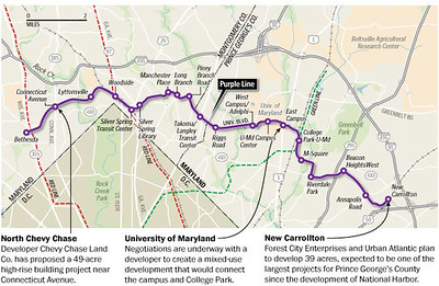
I have a great piece about how the New Carrollton area can be revitalized through repatterning around transit service.  New Carrolton will also be the end point for the forthcoming Purple Line light rail.

-- "Setting the stage for the Purple Line light rail line to be an overwhelming success: Part 4 | Making over New Carrollton as a transit-centric urban center and Prince George's County's "New Downtown"," 2014/2017

Transit oriented development.  This desire is nothing new.  It was a priority for Maryland's Democratic governors, who advocated for a Smart Growth agenda--that is, focusing development on existing places rather than sprawl.  Transit oriented development (TOD) is a land use and transportation  planning approach that intensifies development around transit stations.

It's not particularly pathbreaking in that's how development occurred historically, around train stations and later around streetcar lines ("streetcar suburbs") and subway and other heavy rail lines.

I wrote about this a fair amount in terms of Maryland, because I believe that they didn't really understand that just because there is a railroad or transit station station doesn't mean that it possesses great potential for "more urban" development.   

-- "For TOD to be successful, necessary antecedents are required, there's no magic wand," 2011
-- "What matters isn't "transit oriented development": what really matters is compact development and integrating transportation and land use," 2011
-- "What the State of Maryland still doesn't get about smart growth," 2011
-- "Bad Montgomery County policy/law initiative #1: removing density bonuses for building around MARC train stations," 2012
-- "Planning for intensity of land use: the question is at what scale are we planning?," 2012
-- "Prince George's County still doesn't get "transit oriented development" and walkable communities: Greenbelt edition," 2012
-- "Department of Duh: Apartments not always successful next to transit stations," 2018

General planning documents

-- Trans-Formation: Recreating Transit-Oriented Neighborhood Centers in Washington, DC | A Design Handbook for Neighborhood Residents, DC Office of Planning, 2002
-- Ten Principles for Successful Development Around Transit, Urban Land Institute, 2003
-- Station Area Planning: How To Make Great Transit-Oriented Places, Reconnecting America and Center for Transit-Oriented Development
-- Rails to Real Estate: Development Patterns along Three New Transit Lines, CTOD

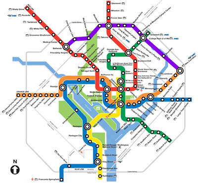
WRT Metrorail, the heavy rail (subway) line serving Metropolitan Washington, once the service started in 1976, it took 10-20 years (1986-1996) to see substantive improvement in core served areas, in particular Downtown DC and Arlington County's Wilson Boulevard Corridor, mostly centered around commercial office development, although in Arlington, also high density multiunit residential.  

In DC, it took at least another 10 years after that (2006) to see the benefit of Metrorail access on community revitalization outside of the core.

Today, in the core of the city with 31 stations (out of 42 total) virtually all of the areas are economically healthy, when in 1976, most decidedly were not.

Categorizing transit stations in terms of access (and indirectly, the opportunity for development.  Perhaps the best way to think about the opportunity for "transit oriented development" is to consider  how WMATA categorizes its Metrorail stations, as laid out in the Bicycle and Pedestrian Access Improvements Study (2010), in Appendix D.  There are nine categories, based on land use context, from dense/connected/compact to undense/disconnected.

  • High Density Urban Mixed-Use in a Grid Network (21 stations)
  • Urban/Suburban Residential Center -- (12 stations) [opportunity for multiunit buildings close to the station, even if the area is otherwise single family residential)
  • Urban Residential Area with a Bus/Automobile Orientation (5 stations)
  • Campus and Institutional (3 stations)
  • Mixed use in a "pod" layout (13 stations) [isolated, disconnected locations]
  • Long-Term Potential for High Density Transit Oriented Development (TOD) or Planned Unit Development (PUD) (4 stations)
  • Suburban Residential Area (9 stations)
  • Auto Collector/Suburban Freeway -- (5 stations) 
  • Employment Center/Downtown/Urban Core -- (12 stations)
Note that to make this typology work more universally, two more categories need to be added:
  • Smaller Town Center (Suburban/Exurban)
  • Exurban Station (Residential primarily)
Using this typology, the seven stations identified by GWP all have serious problems in terms of sparking development, all are pretty much in undense, automobile centric locations, most are pretty distant from Baltimore or DC.   
This illustration from The House Book by Keith DuQuette shows the "transect" of land use context from less dense and more spread out (rural and suburban) to highly concentrated (urban).

One station not included in the list, the West Hyattsville Station in PG County has had a station area TOD plan for 22 years!!!!!!!!! and the area is just now starting to see development.  

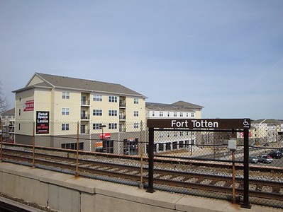
Seemingly it's a good location, about 1.3 miles from the DC/Maryland line, and four miles from the Fort Totten Station, with plenty of land able to be redeveloped and a nearby neighborhood commercial district, and access to trails and parks.  

But until better locations (greater demand, greater economic return) are developed first, the site will continue to lie fallow.


In the Metrorail access study, the difference between the stations is whether or not they are (1) in dense places, either urban or suburban; (2) with an urban form/urban design that prioritizes sustainable mobility (walking, biking, transit); (3) versus a built form that is de-concentrated and automobile-centric; (4) located closer in or farther out in the context of the transit system and the core of a metropolitan area; and (5) end of the line stations.

Stations that are located in deconcentrated places and are car dependent don't particularly lend themselves to compact development.  At best they are pods.  If they do attract residents and tenants, the residents still need a car for most trips and it is difficult for the project to spark further development.

There are many examples of failures to fully leverage transit as a development augur, in places that have better conditions for TOD.  

In DC, the Rhode Island Metrorail station was originally an endpoint station, so commuters drove to the station and parked there.  The area was industrial and when the station was created, the city did not in turn re-plan the area for an urban form more typical of the core of the city.  As a result the station hasn't fully realized its opportunity to reshape the landscape.

It is starting to happen.  The parking lot at the station was redeveloped as apartments (not particularly well, but it did occur), and a nearby shopping center is being redeveloped as a mixed use residential and commercial development.   But this is over a 35-55 year time frame from when the station first opened.  Clearly, a more active station area planning process would have significantly improved the velocity of change.

And the city developed the "Home Depot" shopping center across from the station without replatting the land, thereby failing to fully reap the opportunities presented, and develop it in a more urban and mixed use fashion.

Similarly, most of the developments around Fort Totten Station, also in DC, in an area that was and is comparatively suburban, have failed to take the opportunity to re-plan the area around the station in a more dense, more urban way.

There are plenty of books, studies, journal articles, plans, etc. about TOD.  

What surprised me about advocacy around the Purple Line in 2014, was that it seemed like they were more interested in getting lessons from other light rail systems--because it was the same mode--rather than figuring out very carefully the lessons the Baltimore-Washington area already has to offer, both in terms of creating successful transit networks and the economic development opportunities proximate to transit and how to realize them.

I wrote this piece when I worked for Baltimore County.  I wasn't involved in the master planning process, but I wrote this memo for them, at their request.  (Because it was the Baltimore County Master Plan, I didn't discuss extending the light rail to Columbia in Howard County, another essential step to making the light rail a lot more useful.)


I suggested that they organize the transportation element of the master plan around six principles.  By contrast the county's transportation planner had a pretty convoluted section about fostering TOD through the County Executive's Office. 
  1. Optimal mobility. 
  2. Linking land use and transportation planning. 
  3. Complete streets and facilities.
  4. Transportation Demand Management.
  5. Transit Value Capture/Funding Mechanisms.
  6. Phasing the construction of new infrastructure.
Later in the process I developed my "Signature Streets" concept, but the big point was that to be useful and to make it economically viable to build more densely around transit, the transit system needed to be bigger and better.  It needed to be a network, not a couple of lines, and it needed to serve destinations that are in demand.

Note that Baltimore County is a great example in how transit stations don't automatically create complementary development.  They have three MARC stations on two lines, 11 light rail stations, and three subway stations.  None of the stations is a noteworthy example of TOD.  In fact, the Owings Mills station and adjacent development there is a great example of the difficulty in creating successful TOD at end of the line stations.

Most all of the stations--train, subway and light rail--are located in very undense places or don't directly serve town and employment centers.

Back then I was pretty derisive of what the county had been doing.  But at that time, I didn't really understand how difficult the job of the county's sole transportation planner was, in the context of a county that prioritized the automobile and derided public transit as a service for poor people.  One of the County Executive's top transportation priorities was buying cars for poor people.

WRT what I laid out for Baltimore County, the seven stations listed in the GWP study have similar kinds of issues that hinder the ability to push development forward around those stations.  And like the examples of Rhode Island and Fort Totten Stations in DC, they need to do better physical planning in order to reap the opportunities that could exist.

Note also that creating a regional (Baltimore and Washington) transit system that integrates modes and expands access to service throughout DC and Maryland in this case, but also Virginia with connections to Pennsylvania, Delaware, and West Virginia, makes development at these stations more possible.

Labels: , , , ,

Friday, July 10, 2020

News flash: Lack of housing supply causes gentrification | How to facilitate transit oriented development

This was in my Google News feed yesterday:


Well, it's lack of supply and high demand both...

-- "Why "gentrification" is visible now... the Diffusion of Innovations Curve of Everett Rogers," 2018
-- "Yes the neighborhood will change, but it will take 10-25 years," 2020
-- "The nature of high value ("strong") residential real estate markets," 2017

Link to the article.

There's been a few good threads on the topic of moderate cost housing in cities on the pro-urb e-list.

A person from Boston pointed out something that is too often forgotten, that because geographic and political boundaries are longstanding, cities can't really "grow" and add lower cost land opportunities to the development mix, in terms of infill and redevelopment.

And that land, especially single family detached, theoretically suitable for more intensive redevelopment is poorly placed.

Another writer made the point that as housing demand increases, allowable zoning intensities should increase as well.

That's a way to effectuate policy wrt the fact that since 1930, the US population has increased by 150%.

Montgomery County Metrorail Housing Initiative.  The other day, I mentioned the Montgomery County initiative to provide tax incentives to build housing at Metrorail sites ("A tax break isn't always the "right" priming lever for desired development").  The Council voted to move ahead.

I didn't realize that the intent is to foster high density housing, as indicated in this graphic from Councilmember Riemer's twitter and facebook feeds.

In any case, upzoning at rail stations--heavy rail, light rail, and commuter rail--ought to occur as a matter of course, although as discussed in the past, the ability to actually do this is dependent on a couple factors especially distance from the core.

Stations far from the core have less potential for successful intensity.  In polycentric transit networks, stations distant from the core don't have much potential for intensive, let alone super intensive housing density.

The interesting question is whether or not allowing for much higher than normal density is enough of an inducement for developers to build and potential residents to choose to live in it.

Another issue is that the farther you live from the core, even though there may be transit stations connecting to it, the less people are connected to the core, and therefore the less demand there is for transit use and connecting to the core.

The Purple Line and DC area lessons for transit oriented development (TOD) in Montgomery County.  One of the things that surprises me about the Montgomery County Council initiative is that it doesn't extend to the County's existing MARC railroad stations and the forthcoming stations for the Purple Line light rail line.  Will it take decades for such legislation to be passed for the Purple Line, like it did for the Metrorail stations (e.g., Glenmont opened in 1998; Shady Grove in 1984).

Passenger rail. In the 2017 Purple Line series and follow ups, I suggest:

(1) there be bi-directional passenger rail service on the Brunswick line which serves Montgomery County and DC (this is in various plans but hasn't moved forward, historically the line was inbound in the morning and outbound in the evening, and the areas around the stations were railroad suburbs; demand conditions have changed significantly in the last 60 years);

(2) the proposed infill station at the White Flint redevelopment site be accelerated; and

(3) a split off line/spur along 270 (or from the White Flint area) be developed to provide service to Bethesda, potentially Georgetown, and Northern Virginia ("Maryland HOT lane study versus "corridor management" and regional scaled transportation planning," 2018.

If you could build denser at the rail stations, would that help to get the State of Maryland to actually consider such developments.  (Transit planning is "all fouled up" in Maryland at present because the Republican Governor is for the most part anti-transit, which makes sense, because his previous career was homebuilding.)

Also see:

-- "A "Transformational Projects Action Plan" for a statewide passenger railroad program in Maryland," 2019

Light rail/Purple Line.  But there is no question that there needs to be a push to develop housing at transit stations. In earlier writings about the Purple Line, spurred by a couple conferences about it, held at the University of Maryland College Park, in 2014, I wrote some about this, and this piece from 2017 synthesized and updated it:

-- "Part 6 |  Creating a transportation development authority in Montgomery and Prince George's County to effectuate placemaking, retail development, and housing programs in association with the Purple Line"

I was surprised at the conference is that they were focused on "learnings" from other light rail systems, particularly in Minneapolis and Denver, because that is the same mode as the Purple Line, and didn't take the time to codify lessons from the DC area's own Metrorail.

Although I get that the key learning was that you line up financial support before the line opens, not after--in both cities it came from foundations, but all in all it wasn't a whole lot of money, and in the context of the DC area, not nearly enough to make a difference.

In Montgomery County, development at the Long Branch and University Boulevard stations in the eastern county could be spurred by inclusion in the new legislation.

Chevy Chase too, although that would be more controversial because the land use context currently is much less dense.  But as a high demand area of the county, adding housing there would be a no brainer.

Density bonuses and implementation mechanisms are necessary to facilitate transit oriented development.  AND STATION AREA PLANS.  The biggest lesson for me is to put in place design and intensity inducements sure. But also implementation mechanisms.

Because the reality is that at the outset, demand, economics, and real estate financing conditions don't favor such intensive development.

That's why you have four story housing at the Fort Totten Metrorail Station. It's an in-city location, but in a suburban patterned land use environment. Rhode Island Station is more urban (but with land pattern problems) and it still has four story apartment buildings, built relatively recently.

fort_totten_metro
I can't remember when this project was built, probably before 2008.  Since then, garden apartments a little further away have been or are being redeveloped into a much denser housing and retail development called Art Place at Fort Totten, and about half mile away is where JBG built housing with a Walmart on the ground floor (I've argued this should have been a bigger project, given its proximity to Metrorail.)  

Unlike with the West Hyattsville station, which has a station area plan, even if it's taken 15 years to start to see some response, DC didn't do a larger scale station area plan for either Greater Fort Totten or Greater Rhode Island Stations, so there are plenty of lost opportunities for not just more intense development, but the creation of a real center in a neighborhood that doesn't have one.

(Intensity is coming to the Rhode Island Station area, but it's taken decades longer because of the lack of a plan, and it comes with a lot of opposition and difficulty.)

Equity considerations/affordable housing.  These implementation mechanisms are more likely to be nonprofit, or at least to require a lot of subsidy, to be able to afford to build by leading the market.  And that sets the stage to include a lot of affordable housing in the projects.

While not included as a case study at those conferences, Phoenix might be a better example than either Denver or Minneapolis in terms of operating at a greater scale, especially in terms of lining up money in advance of the light rail's opening to fund affordable housing ("Light rail housing fund spurs 15 projects in metro Phoenix" and ""Why you don't see more vacant lots along light-rail route,"Arizona Republic).

The Phoenix program hasn't involved a lot of money, although none of the projects are particularly large.

Prince George's County.  Note that this entry has been about MoCo because of the current legislative initiative.  But all of these issues pertain to PG County too: the need to repattern land use around transit and transit stations; to add intensity; to provide ways to improve demand along at least one MARC rail line (Camden) and to add the opportunity for infill stations on or extensions from the Penn Line, etc.

For example, with an integrated rail passenger service on the Penn Line in Maryland and the Fredericksburg Line in Virginia ("A new backbone for the regional transit system: merging the MARC Penn and VRE Fredericksburg Lines"), it could be advantageous for PG County to add an infill station in Landover, etc.

Labels: , , , ,

Monday, July 06, 2020

A tax break isn't always the "right" priming lever for desired development

The Washington Business Journal reports ("Montgomery County eyes property tax breaks for projects on Metro-owned sites ") that Montgomery County Council is considering a 100%, 15-year tax break, to speed up housing development at Metrorail sites.  From the article:
Legislation on the subject is set to be introduced at the County Council Tuesday as part of an ongoing effort by a group of lawmakers to ramp up residential development in the Maryland suburb and help the county realize its housing production goals. This new tax incentive, along with a host of others, has been in the works for months.

This latest measure, authored primarily by Councilmen Andrew Friedson, D-Bethesda, and Hans Riemer, D-At large, would create a payment in lieu of taxes program for any private developer leasing land from Metro to construct new high-rise buildings.

The bill would abate 100% of real property taxes for these projects for up to 15 years, starting when use and occupancy permits are issued for the property. County staff would then negotiate some other form of payment with the developers in question, though the legislation does not set standards for that process.
Stations with the most opportunity for complementary real estate development tend to be closer in.  FWIW, I have written many times that there is no such thing as "automatic" TOD (transit oriented development).

WMATA Map showing the Purple Line (but not the Silver Line)Metrorail Map showing the Purple Line light rail line, which is currently under construction.

For various reasons, especially stations farther from the core of a metropolitan area, housing is less attractive and still requires a car, even if it's located at a transit station. This is true for light rail, heavy rail, and commuter rail.

-- "Prince George's County still doesn't get "transit oriented development" and walkable communities: Greenbelt edition" (2012)
-- "With "transit-oriented development" urban design and/or planning is destiny" (2009)

Glenmont Station is about 12 miles from Downtown DC.  Forest Glen is closer, but is bracketed by the I-495, the Beltway Freeway.  Shady Grove is 24 miles from Downtown DC.

I don't think the issue is taxes.  Developing on transit agency land is really hard.  (1) Cost in terms of money and time is an issue, because the development process for transit agency land is super convoluted because it takes an inordinate amount of time, for example, the development at the Takoma Metrorail Station has been "underway" for 20 years !!!!!!!!!!!!! and is no way near any resolution.

(2) Besides the problems of contracting with a government agency anyway,  (3) it requires a federal review, since federal funds had been involved in the development and operation of the system; and (4) residents opposed to development seek various additional reviews and often the intercession of the Congressional representatives. 

Hard projects get developed once all the easy sites are taken.  If (5) the station isn't well located relative to housing demand, that makes it even more difficult.

While not in Montgomery County, but in Prince George's County, there has been a transit development plan for the West Hyattsville station for at least 15 yearsAlthough last year WMATA did sell land there, and a development program is apparently underway.

The problem is, more marginal development sites won't get developed til all the better sites are developed successfully.

Basically, the "problem" in Montgomery County is the stations that haven't been developed, in particular Shady Grove and Glenmont, are distant from the core and don't possess the characteristics that tend to draw "urban-oriented" residents who are the kind of people who want to live in housing at transit sites.

A tax break isn't going to change that reality.

More importantly, rather than offering a tax break willy nilly, I'd offer a tax break conditional on a plan and program for achieving multiple planning-related objectives.  The article says that's intended, but not defined in the legislation.  That's never good.

Purple Line and TOD tax breaks.  Because they'll be closer in, I'd say with the Purple Line, at the very least the Chevy Chase (Connecticut Avenue) station will be more in demand--also because it's in a much higher income area--than the outlying Metrorail Stations, while the Long Branch Station will not be, because it's in a lower income area--even though both stations will be located about 7 miles from Downtown.

I'd consider including stations like that, where the normal development timeline would be much longer, for tax breaks over a station like Shady Grove or Glenmont, because Purple Line stations are closer in, closer to the core, while Shady Grove and Glenmont are end of the line stations that are very suburban, and lack the pre-conditions for urban intensity.

Labels: , , , ,

Tuesday, October 22, 2019

Because I misread this, I thought it was a big deal. It wasn't and it proves the point I made in 2014 about the need for Montgomery and Prince George's County to create a Purple Line focused community development corporation

Hampshire Village in Langley Park.

I guess my eyesight is going because when I first saw this Washington Post article headline, "JPMorgan Chase commits $5 million to combat gentrification along the Purple Line," I read million as billion.  First I thought it was a big deal, at $5 billion.  But $5 million for "fighting gentrification" in a rail corridor that will have 20 stations over 16 miles is a drop in the barrel. From the article:
A major national bank has committed $5 million to nonprofits to support affordable housing and small businesses threatened by development expected to follow the Purple Line being built in Washington’s Maryland suburbs.

The award by JPMorgan Chase, announced Tuesday, is the largest grant so far for efforts to combat gentrification that could displace residents along the 16-mile route of the light-rail linelinking Bethesda in Montgomery County and New Carrollton in Prince George’s County.

The investment, spread over three years, aims to help preserve or create 1,000 affordable homes, according to a draft news release obtained by The Washington Post.
Purple Line routing and station map

And that's the point I made going to conferences on the Purple Line sponsored in 2014 by the University of Maryland National Center for Smart Growth.

-- "To build the Purple Line, perhaps Montgomery and Prince George's Counties will have to create a "Transportation Renewal District" and Development Authority"
-- "Quick follow up to the Purple Line piece about creating a Transportation Renewal District and selling bonds to fund equitable development"


Victoria Crossing apartments, Langley Park.

Although it turns out I made the same point in 2009.  (Although changes to the google and blogger search functions make it virtually impossible to find the link at the moment.)

This point later was the foundation of a related concept, the creation of tax increment financed "public improvement districts" for transit station catchment areas as a matter of course.  PIDs are a pretty common technique, but are not often integrated into transit line development programs.

-- "Public improvement districts ought to be created as part of transit station development process: the east side of NoMA station as an example," 2016

 And of course, I restated it as part of the 2017 series on focused leveraging of the Purple Line infrastructure program to drive economic development and transportation improvements more broadly:

 -- "Part 6 |  Creating a transportation development authority in Montgomery and Prince George's County to effectuate placemaking, retail development, and housing programs in association with the Purple Line"

Basically, you need an entity that can buy, hold, finance, intensify, and build if necessary housing and commercial property in the Purple Line corridor, if you want to accomplish multiple objectives that are sometimes counter to each other, such as growth vs. limitations on displacement; growth of rent asking prices (seen as a benefit from the standpoint of real estate ownership) vs. maintenance of low rents, etc.


Creating a Bi-County Redevelopment Authority with bonds (tax increment financing) sold "against" a Transportation Renewal District comprised of the catchment area of the Purple Line light rail line in Montgomery and Prince George's Counties, Maryland

1. The idea is to create a companion "Revitalization District" that wraps around the newly created transportation infrastructure, and create a "Tax Increment Financing" program to raise a very large fund, which could increase significantly the velocity of revitalization, and to purposefully fund the kinds of equitable development activities espoused by the Purple Line Corridor Coalition.
Subareas, Purple Line Transit Corridor, Montgomery and Prince George's Counties, Maryland

2. Rather than creating a variety of micro-TIF districts for various projects, this proposal is for a large single fund, but with a detailed program facilitating projects at various scales and locations, but using the large tax district as a way to realize projects across all parts of the catchment area, including areas where current demographics and economic conditions wouldn't normally support financing for such projects.

3.  Originally I did not foresee using TRD monies to fund the construction of transit infrastructure per se, but to fund new property development by both for profit and nonprofit entities, property acquisition to maintain long term affordability, civic infrastructure, and community improvement programs of various types.

Now I would include transit network improvements as eligible for funding, and would even consider using a portion of the revenue stream to fund the actual construction of the Purple Line specifically.

4.  The lessons from DC and Portland's use of an Urban Renewal District to fund some of the local match for its Yellow Line light rail is that it takes 30-40 years to see fully the impact of the transit line on ancillary investment, so the TRD needs to be set up to last a long time--typically an urban renewal district's funding is for a 20 year period and then ceases, although Portland has a process for extending the period.

5. Recognizing that new development results in new costs for existing systems like emergency services and schools, "all" of the forecasted increase in property taxes should not go to the TRD, some of the stream should be reserved and fund such services.

6.  Action plans would need to be created, along with the right accountability mechanisms and marketing systems, along with some flexibility to respond to changes in market conditions, circumstances, and opportunities as they development.  A supra-prescriptive plan isn't the right course, but a set of "transformative projects" should be part of the program (see "(Big Hairy) Projects Action Plan(s) as an element of Comprehensive/Master Plans"--now I am calling such plans, "Transformational Projects Action Plans").

Labels: , , , , , , ,