Rebuilding Place in the Urban Space

"A community’s physical form, rather than its land uses, is its most intrinsic and enduring characteristic." [Katz, EPA] This blog focuses on place and placemaking and all that makes it work--historic preservation, urban design, transportation, asset-based community development, arts & cultural development, commercial district revitalization, tourism & destination development, and quality of life advocacy--along with doses of civic engagement and good governance watchdogging.

Tuesday, August 29, 2017

Urban design considerations for the area around Washington Nationals Baseball Stadium in advance of the 2018 All-Star Game

The current controversy over the name of  the gateway to Fenway Stadium, Yawkey Way ("The Red Sox, the Confederacy, and Changing the Name of Yawkey Way," The Nation) in Boston, reminds me that since this past April's opening day for the Washington Nationals baseball team, I 've been meaning to write about the urban design-placemaking aspects of the area around the Stadium in Southeast Washington.

This matters a lot generally, but also "right now," because next year, the stadium will host the Major League Baseball All-Star Game, and  will showcase, for good or bad, the neighborhoods in Southeast and Southwest nearby and adjacent to the stadium.

Now, I don't think the All Star Game will be a major moneymaker the way that touts claim ("The 2018 MLB All-Star Game could bring $100 million to D.C., economists say," Washington Post) as most of the revenues will be absorbed by Major League Baseball and travel and hotel companies, with little money remaining to be recirculated around the city.

But I do think it will be a great marketing opportunity for the area around the stadium--Capitol Riverfront and the Navy Yard District in Southeast, and the new Wharf District development on the Washington Channel in the adjacent Southwest quadrant--the development will be opening this fall.

Plus, regardless of the microeconomic impact, the All Star Game will bring tons of attention to DC, and why shouldn't we ensure that this attention shows the city in the best possible light?--especially the "local city" as opposed to the narrative of the city as the national seat of government, a reputation which is now deeply negative.

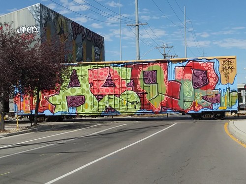
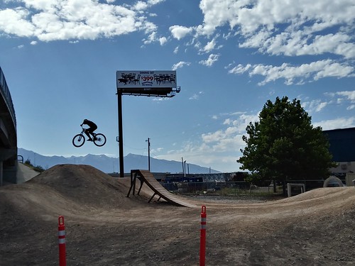
Unfortunately, the development of Half Street SE, the gateway into the Stadium from M Street SE and the Navy Yard Metrorail Station, is many years behind what was planned, as a result of 2008's Great Recession, which delayed by many years work on properties in this area. 

Today the entryway into the stadium is sub-par and grim.

Half Street SE looking north from the Washington Nationals Baseball Stadium

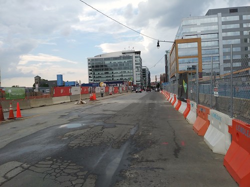
Although major buildings are under construction on N Street--the street in front of the stadium--and on Half Street, but it's unlikely that the ground plane of the buildings has been designed to be more like streetfronts and streetscapes of old, as demonstrated by the building already extant, and housing an entrance to the Metrorail station.

According to a now out-of-print publication produced by the Downtown DC BID, the Principles of Quality Storefronts include:
  • Display Bays Every 20 Feet
  • Continuous Storefront Retail
  • Sidewalk Merchandising
  • Colorful Banners & Awnings
  • Inviting Displays & Attractive Merchandising.
The Navy Yard Metrorail Station at 1200 Half Street SE, Washington DC
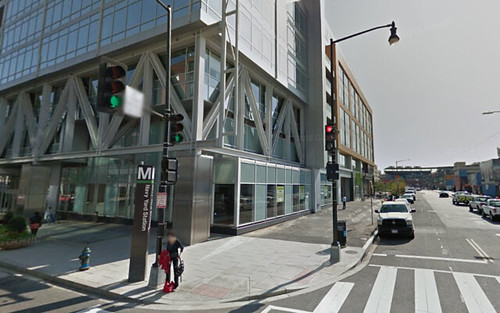
Building at the southeast corner of Half and M Streets SE.  Google Street View image.

Office buildings tend to extend their façade design as a continuous wall from top to bottom without making special considerations for ground floor spaces intended for retail use.  In these cases, the spacing of the storefronts, the size and design of the windows, and the height of the first floor tend to be out of sorts compared to expectations.

There should have been special urban design guidelines created for a "Stadium Special Design District," to ensure that the ground plane-built environment to be constructed on Half Street and N Street provided the best possible experience in terms of the Principles of Great Streets:
  • Great Buildings & Storefronts
  • Walkability
  • Mixed Uses
  • Great Food
  • Great Stores
  • Vibrancy & Sociability.
Focusing on the urban design of Yawkey Way rather than its name, clearly the physical environment  augments the Game Day experience through the urban design of the buildings, the punctuation of the storefronts, the streetscape, and the types of businesses located in the storefronts.
    Yawkey Way
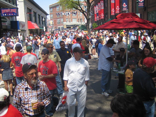
    Flickr photo by Shawn Morrison who writes: They close off Yawkey Way before games now. It's like a carnival, bands playing all sorts of food and every variation on Red Sox clothing you could possibly imagine.

    Half Street and N Street pale by comparison.   Clearly, at this stage of development, the built environment side of the stadium is under-developed and fails to show off in positive ways its urban location.  

    Of course, the Baltimore Orioles stadium, Camden Yards, is another example, which ushered in the era of "throwback" stadium architecture.

    While I would argue that that stadium's economic impact has been somewhat overstated based on the pace of revitalization in the West Side, as well as the lagging improvement of neighborhoods further west but within easy walking distance, the architecture and urban design principles exhibited in the final product have been top notch. 

    Similar to Yawkey Way, Eutaw Street along the stadium is pedestrianized and has the right scale and punctuation. It's not a streetwall of office buildings.
    Pedestrianized Eutaw Street adjacent to Camden Yards
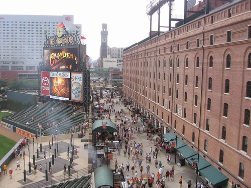
    Pedestrianized Eutaw Street adjacent to Camden Yards.  Photo by Klaus Philipsen, "Oriole Park at Camden Yards: Still the Model for Urban Ballparks.


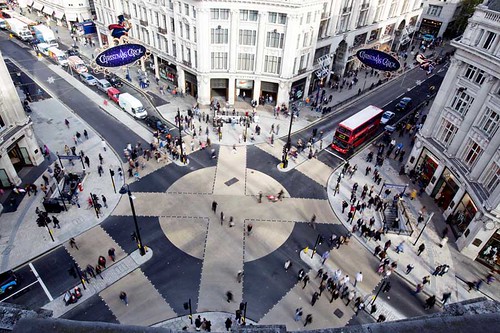
    Perhaps when the area around Nationals Stadium is finally "built out," DC will go back and redo the street treatments here, such as creating an in-street plaza comparable to that of Oxford Circus in London. 

    Note that my understanding is that there are plans to change the pavement materials of the street making it more plaza-like, maybe to make it function more like Yawkey Way on game days, where the street could be closed off to traffic.

    Oxford Street, London, at Night.
    London Christmas 2013 - Oxford Street

    Oxford Street Circus Intersection with Diagonal Crossings for PedestriansImage from E-Architect.  Note that this street treatment was introduced in 2010, two years before London hosted the Olympics, and this timing was deliberate.
    oxford street "circus" intersection, diagonal

    While it's not a direct example of the right kind of treatment for Half Street which ought to be termed "Nationals Way" now, Nashville's widening of sidewalks on Lower Broadway--a street with a great deal of pedestrian traffic--and the addition of bollards ("Nashville's Lower Broadway is getting a new look to improve safety along tourist thoroughfare," Nashville Tennessean) shows the kind of street treatment that ought to be happening on Half Street SE as a gateway to the stadium.
    Before and after visualization of streetscape improvements to Lower Broadway, Nashville
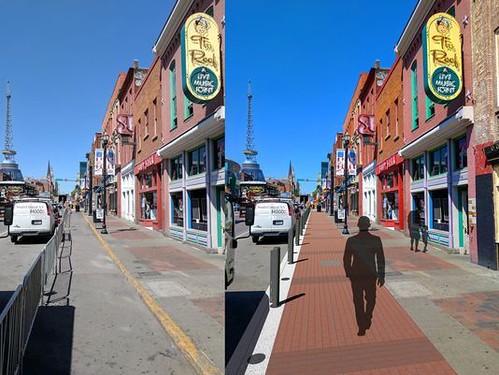
    Before and after visualization of streetscape improvements to Lower Broadway, Nashville.  Image: Nashville-Davidson County Planning.

    Sadly, these kinds of improvements should have happened before the All-Star Game next year, just as London made a great many public space, street, and transit improvements in advance of the 2012 Olympics. 

    It's incredible that only this year have stakeholders started thinking more directly about preparing for the All-Star Game, based on this report, "Having taken measure in Miami, Nationals and D.C. now on the clock for 2018 All-Star Game," from the Washington Post. From the article:
    It was a point that was not lost on any of the dozen or so Nationals employees scattered around Marlins Park for Tuesday night’s game, or the nearly 30 who had cycled in and out of Miami over the course of the past week to observe, take notes and otherwise learn the ins and outs of running one of baseball’s jewel events — which, more than a single baseball game, is a massive, week-long festival that stretches the resources of both the host ballpark and its city. The 2018 All-Star Game will be the fifth held in Washington but the first since 1969.

    “This is what we asked for,” said Gregory McCarthy, the Nationals’ vice president of community engagement. “This is what the team and [D.C. mayor Muriel E. Bowser] said to Major League Baseball: ‘We can do this.’ It’s a lot of work. But Washington does these events well. We do big events on this scale probably more than any other city.” ...

    “For people who were involved in bringing baseball to D.C. 13 years ago, it’s another milestone for Washington being validated as a great sports town,” McCarthy said. “What’s neat about it all is, if you’re a die-hard baseball fan, you’ll find [the All-Star Game] to be a validating, enjoyable experience — for the experience and grandeur of the event, it’s the tops in the sport. But then, there are other events that appeal to the less-intense fans and people who aren’t baseball fans necessarily. That’s the great opportunity we see, the ability to get people from D.C. and the region from all persuasions engaged in all-star week.”
    It's too bad that the date wasn't shifted back a couple years, to 2019, 2020, or 2012, when the area around the Stadium is much likely to show better than it will next year.

    This is an example of how difficult it is to coordinate land use development actions by the public and private sectors for optimum results.

    It definitely calls attention to the need for the creation of special design requirements in association with large projects and wide-scale redevelopment plans before the development starts, rather than long afterwards, when there are few opportunities to have impact even in the face of predictable sub-optimal outcomes.

    Labels: , , , ,

    National Freeway Free Speech Weekend Scheduled for Sept 2nd-4th

    Press release:

    National Freeway Free Speech Weekend Scheduled for Sept 2nd-4th
    Signs with Political Messages to be affixed inside Freeway Overpasses nationwide

    This Labor Day weekend, Americans will be posting signs with political messages on the inside of freeway fences.

    Since people travel on freeways and highways in numbers larger than ever, this simple act allows their voices to be heard, or at least seen, by thousands.

    A form of local, meaningful action, people will be flexing their free speech by making signs that abide by our First Amendment (non-commercial, non-threatening, and cannot advocate for violence, political or otherwise) and securing them across America.

    · WHO: The American Public, expressing their political opinions en masse

    · WHAT: A free speech event wherein people will create large political signs, and safely hang them along freeway fences and overpasses

    · WHERE: Communities across America

    · WHEN: Labor Day weekend, September 2-4, 2017

    · WHY: With the heated rhetoric happening among our politicians, media, and even family and friends, many feel unheard. But, National Freeway Free Speech Weekend gives people the opportunity to easily, quickly, and effectively make a statement.

    Signs along highways and freeways reach thousands (sometimes hundreds of thousands) in an effective, safe way. Now, more than ever, it is our duty to use free speech responsibly and be empowered by this constitutional right.

    Participants must ensure they create and affix signs safely (DIRECTIONS).

    Examples of signs that have been posted in the past.

    If you plan on participating, please respond with what city you will be representing and forward photos of your sign(s) to freewayblogger@yahoo.com or post on Facebook to be featured in the Freeway Blogger Blog.

    Labels: , , ,

    Monday, August 28, 2017

    Funding WMATA by a regional sales tax

    I haven't been writing about WMATA, the DC area subway and regional bus system, and its financial issues because it's been overwhelming. 

    The steady drumbeat of bad news about the Metrorail system has overwhelmed my capacity to write about it.  There are just so many countervailing and conflicting issues that it makes it difficult to write the kind of supra-authoritative pieces that I tend towards.

    Fortunately, even though the situation is complicated, I can fall back on a large body of work on the topic that I have produced over the years, including these broad themes:

    1.  Needing to rebuild a regional consensus about what transit means, its importance, and how to go about achieving it

    • St. Louis regional transit planning process as a model for what needs to be done in the DC Metropolitan region, 2009
    • TriMet (Portland): CHALLENGES & CHOICES A Budget Discussion Guide, 2012
    WMATA 40th anniversary in 2016 as an opportunity for assessment, 2014

    2.  The failure of the area's Metropolitan Planning Organization, tasked by the federal government to do and coordinate transportation planning to execute that role to its logical extent, so that by default WMATA ends up being the primary metropolitan transit planner by default

    • Metropolitan Mass Transit Planning: Towards a Hierarchical and Conceptual Framework, 2010
    • Without the right transportation planning framework, metropolitan areas are screwed, and that includes the DC area, 2011
    Route 7 BRT proposal communicates the reality that the DC area doesn't adequately conduct transportation planning at the metropolitan-scale, 2016

    3. Various pieces about WMATA's current conditions in operation, financing and governance shaping today's crises

    • Defining service standards down as an indicator of breakdown in metropolitan transit planning, 2012
    • Getting WMATA out of crisis: a continuation of a multi-year problem that keeps getting worse, not better, 2015
    What it will take to get WMATA out of crisis, 2015
    What it will take to get WMATA out of crisis continued and 2016's 40th anniversary of WMATA as an opportunity to rebuild, 2015
    WMATA and two types of public relations programs, 2015

    4.  Related to point #2, it is possible to redesign the metropolitan and regional transit system in ways that achieve more and better service, but I am not holding my breath:

    Will buses ever be cool? Boston versus the Raleigh-Durham's GoTransit Model, 2017
    One big idea: Getting MARC and Metrorail to integrate fares, stations, and marketing systems, using London Overground as an example, 2015
    The answer is: Create a single multi-state/regional multi-modal transit planning, management, and operations authority association, 2017

    Competing recommendations.  There have been a variety of competing recommendations for its management and funding ("Metro GM proposes 'new business model' and $500 million a year in extra funding to save D.C.-area transit agency," Post), Virginia has organized a review led by former Secretary of Transportation Ray LaHood, and now there are proposals to enact a regional sales tax ("Regional Officials Call For Sales Tax To Fund Metro," WAMU/NPR).

    For me, the various proposals and reports illustrate once again the reality that our region doesn't do true "regional transportation planning."

    Ideally, the organization tasked with transportation planning responsibilities for the DC region, the National Capital Region Transportation Planning Board, would have led an impartial effort to figure things out.  What the problems are, what potential solutions could be, what the options are.

    THAT hasn't happened.  At least not the way that I would do it.

    The MWCOG did do a study, which recommended a sales tax, but the report ("COG analysis of Metrofinds more than $7 billion shortfall in capital and maintenance funding, presents options to close the gap," MWCOG press release) did not lay out all the possible options in the way that the Metrolinx report does.

    The result is suboptimal outcomes.

    Although in fairness to the Council of Governments, the fact that the system is in crisis now--the report outlines major funding gaps and argues that an additional revenue stream provided by dedicated funding is necessary by 2019--precludes a judicious consideration of the issues, and lining up support for the best funding program, which in the best of circumstances, takes years.

    Crises are a bad time for innovation and measured thought.  While Rahm Emanuel has a famous quote about not letting crises go to waste, my sense is that crises are terrible times for innovation, because people are too confused and desperate to consider and reason clearly.
    "You never let a serious crisis go to waste. And what I mean by that it's an opportunity to do things you think you could not do before." -- Rahm Emanuel
    The debacle with WMATA--managing it, funding it, operating it--is proof that most places aren't capable of rising to the occasion of a crisis.   Furthermore, even in the best of times, it takes jurisdictions a long time to create the necessary consensus to support big projects, big funding initiatives, etc., especially in a region that does do big projects, but in a one-off rather than a coordinated fashion.

    Report for Metrolinx lists 25 options.  I'm fond of a report done for Greater Toronto's Metrolinx, which listed 25 different funding options.  By including the full list, I don't mean to suggest that we need to enact every one of those taxes, I just like being able to see a complete list.

    Personally, I think the best option would be to do a transit withholding tax--something that is done in parts of Oregon, in the area served by MTA (railroads and transit in New York City) in New York State--which was pioneered by the French with what they call the versement transport.

    In France, governments are not exempt from the versement transport.  In Oregon and New York, governments are mostly exempt, in particular the federal government.  For this to work in the DC area, the Federal Government would have to agree both to allow their employees to be taxed and to pay the tax. In the current political environment, this will never happen.  Therefore, while ideal, it's not practical.

    The WMATA sales tax proposal.  The sales tax proposal is controversial because:

    (1) some jurisdictions don't want to participate

    (2) certain advocacy groups argue that a sales tax is paid disproportionately by the less well off, who are more dependent on transit, but don't ride the subway as much and so they don't support a sales tax surcharge for transit ("Ahead of regional summit, left-leaning policy groups say 'No' to a sales tax for Metro," Post; Triple Whammy: A Regional Sales Tax for Metro, Like Fare Hikes and Service Cuts, Would Fall Hardest on Struggling Families, joint report by the DC Fiscal Policy Institute, Maryland Center on Economic Policy, and The Commonwealth Institute)

    (3) DC Council Chairman Phil Mendelson argues that the funding formula for WMATA should be revised because DC pays disproportionately in terms of population ("New dispute over cost of fixing Metro pits District against Virginia, Maryland," Post)

    (4) but the Washington Post disagrees with Mendelson ("The District’s death wish for Metro"), accusing the city of threatening Metro's success by complicating approvals for a dedicated funding stream.

    Meanwhile, I lament that a reasoned approach to analyzing the options and making recommendations wasn't taken.

    For example, counter to the Post's assertion, it is reasonable to make the regional funding system for WMATA to be "more equal," because DC pays more than it should based on the fact that many of the daily users are commuters and their income tax revenue goes to Maryland and Virginia.

    Originally, too I was somewhat concerned about "a sales tax for WMATA" because I think it should be a "sales tax for transit," with the funding stream opened up to other transit investments.  That bothers me still, but a little less, because a recent Caltrain sales tax initiative--which would be assessed in addition to sales taxes that fund the Bay Area Rapid Transit (BART) system--is moving forward ("Poll: Caltrain sales tax hike draws huge voter support," San Jose Mercury News).

    But since the desire for funding has been driven by crisis--the need to get WMATA to a place where they can do large scale debt financing--a reasoned consideration of the options hasn't occurred.

    My recommendation: a combination of sales and property taxes.  Personally, I think a combination of sales taxes and a graduated property tax surcharge is in order.  By graduated tax, I'd argue that properties within the defined "transit shed" of the Metrorail system should pay at a rate reflecting the proximity to the network.  Closer in properties should pay more than those farther out.

    (Note that we must recognize that when the economy undergoes recession these funding streams aren't impregnable--they drop too as many transit agencies relying on such tax streams were driven to the brink of disaster during the Great Recession.)

    Tennessee does what Washington should have done: creates a transit funding calculator.  Nashville doesn't have rail transit, and they are considering it, along with other boosts to transit including bus rapid transit.  As part of the process of consideration of transit expansion and how to fund it, the Nashville Tennessean reports ("How much could different taxes generate for transit in Nashville region? There's now a calculator"):
    ... there's now an easy way to calculate the transit funding potential of four tax possibilities: increasing to sale tax, property tax, hotel/motel tax and wheel tax.

    On behalf of the Nashville Area Chamber of Commerce, William Fox, professor of business and economic and the University of Tennessee, has created new revenue forecast models, Nashville Transit Revenue Forecast Model, that projects funding capacity over time for each of these taxes.

    "We've developed the capacity for you to develop and create your own revenue estimates," Fox said at a Wednesday meeting hosted by the chamber to roll out its Moving Forward transit group's latest report. "It is so easy to use. Anybody can run this model easily and quickly." ...

    There are different models for 10 counties including Davidson based on historic patterns and growth forecasts. It allows anyone to go online and see the potential of raising one of the four taxes by a certain percentage. The tool also allows one to see the impact of raising a combination of the four taxes.
    The advantage that Tennessee has though is that they are at the start of their process.  Similarly, the BART system is funded in part by a sales tax assessed in participating jurisdictions. Same with Greater Atlanta, some counties opted out of participating in MARTA, which they mostly now regret.  Creating a dedicated funding system for WMATA should have been done at the start of the project, not 40+ years in after the system opened, and 50+ years if you start counting the planning, design, engineering, and construction period before the system opened.

    26 ways to tax to fund transit
    (Based on the report, Big Move Implementation Economics: Revenue Tool Profiles, produced for Metrolinx Toronto by AECOM and KPMG)

    • Auto Insurance Tax
    • Car Rental Fee
    • Carbon Tax
    • Cordon/Congestion Charge
    • Corporate Income Tax
    • Development Charges/Impact Fees
    • Driver’s License Tax
    • Employer Payroll Tax (Versement Transport)
    • Fare Increases
    • Fare Surcharges (There is a fare surcharge to use the SFO Airport via the BART system; "BART cuts surcharge for SFO workers," San Francisco Chronicle; Boston's Logan Airport is considering surcharges for passenger drop off and pickup to encourage use of transit, "Dropping off a friend at Logan? It could cost you," Boston Globe)
    • Fuel Tax
    • High Occupancy Tolls
    • Highway Tolls
    • Hotel & Accommodation Levy (Hawaii is about to approve this type of tax to help fund the commuter rail system in Honolulu, "After reaching deal, lawmakers to meet for special session on Honolulu rail funding," Hawaii News Now)
    • Income Tax
    • Land Transfer Tax
    • Land Value Capture
    • New Vehicle Sales Tax
    • Parking Sales Tax
    • Parking Space Levy
    • Property Tax
    • Sales Tax
    • Tax Increment Financing (Special Assessment Districts)
    • Utility Levy
    • Vehicles Kilometers/Miles Travelled Fee
    • Vehicle Registration Surcharges (this is allowed in Washington State, through what is called a Transportation Benefits District, and in the Puget Sound, a Regional Transit Authority fee for Sound Transit)

    Labels: , , , , ,

    Friday, August 25, 2017

    Postcard exhibit at DC Chapter of American Institute of Architects

    The Post columnist John Kelly writes about the current postcard exhibit at the DC chapter of the American Institute of Architects, Wish You Were Here! Vintage Postcards from Washington, D.C. which is up through Friday September 8th  ("Postcards from paradise — or at least from Washington, D.C.").

    On Thursday August 31st, there will be a talk, "Greetings from Hometown Washington, DC," about the exhibit, by Jerry McCoy, a DCPL librarian, avid postcard collector, and chair of the Silver Spring Historical Society.

    The exhibit is cool and worth looking at.  One neat element is that the exhibit includes items from a number of DC institutions and private collectors.

    I saw a bunch of postcards I hadn't seen before--but I found it somewhat disappointing because while the didactics discuss how postcards were used to send messages and communicate, no backs of postcards/no messages are displayed.

    In their own right, backs of postcards are also interesting in how the printed text communicates about the value of what is displayed on the front. 

    Backs of the postcards may include text and logos from "sponsors" be it a local motel or a railroad line, which made postcards available on signature passenger trains.

    Besides the great images depicted on the fronts of postcards, I like postcards because of the text of the message, where people describe their impressions of the city, what they did and where they visited, etc.

    When I picked up this card in Seattle (left), because the front is nondescript (a 1960s era card), my partner asked me why I bothered. I said, read it.

    The writer-sender described being in the city to attend a conference and the inconveniences posed by there being a massive anti-war demonstration at the same time.


    Finally, backs of postcards can be interesting because of the postmarks. Some individual post offices cancelled their own mail. I have postmarked cards from Brookland, Takoma Park, and Union Station in DC, and Ballston, in Arlington County.  (I might have one from Silver Spring, Maryland too.)

    It would have been interesting to show such cards also--Georgetown had its own cancellation pre-1900, but I haven't been able to find one after that time frame.  But I keep looking...

    This postcard back (an image from the Internet, not in my possession) shows both this kind of message as well as a localized postmark from "Terminal (Union) Station."
    Washington Union Station postcard, postmarked 1913, with "Terminal Station" indicia

    In terms of the mounting of the exhibit as pointed out in the Kelly column, part of the show is displayed behind a table under the stairs making it extremely difficult to view the postcards shown in that section of the exhibit.  Although it is nice that each original card was scanned and is shown at a size larger than real life.

    For people interested in postcards and urbanism, the great book by Alison Isenberg, Downtown America: a history of the place and the people who made it (commentary), which analyzes the impact of the Depression on downtowns and the real estate industry, uses the postcard archives of the former Curt Teich Company to illustrate and discuss how communities portrayed and marketed themselves.

    Finally, one of the great things about collecting postcards of "Washington" is that because of people visiting here and communicating with people "back home," you can find great Washington ephemera all over the country.

    E.g., a Shell gas station road map of DC dated 1966 that I picked up in Richmond shows the then proposed freeway routes that were successfully fought off later in response to a citizen campaign against the freeways.
    Washington DC Shell Oil map, 1966

    Labels: ,

    Thursday, August 24, 2017

    Graffit-ed box car as public art

    When I saw this car, I wondered if it had been done with the approval of the train car owner, because the specific identification information for the train car was not obscured by the paint job. 

    Then, it made me think, why not have a "public art" program featuring art graffiti treatments of box cars?  It certainly would be a way for a transportation company to differentiate their brand.  Although most in the industry would probably frown on the choice, believing it would encourage graffiti where it wasn't wanted.

    -- "The Art of Freight Train Painting," Saturday Night Magazine, Canada, via Utne Reader
    -- "We were here: Marks, Monikers, and the boxcar art tradition," Matthew Burns, masters degree thesis, Lehigh University, 2005

    Although I am not sure this is what I meant when I lay out the concept of "transportation infrastructure as an element of civic architecture."

    Graffiti-ed box car

    Revisiting the need for "Tower renewal" (multiunit) programs

    One of the unintended consequences of the kind of "fractional ownership" that is created by condominiums is that when properties are on the decline, it can be difficult to get a majority of owners to agree to take the necessary steps to arrest the decline, and that's the case even if they have access to financing, which in the case of many declining properties is not the case.

    -- "The long term potentially negative aspects of condominium buildings as a dominant housing form in cities," 2016
    -- "Deeper thinking/programming on weak residential housing markets is required: DC example, Anacostia," 2012

    The US Department of Housing and Urban Development has long had a program designed to help fund renovation of aging multiunit affordable housing buildings.

    But as multiunit buildings age, support programs may be needed whether or not the buildings are "affordable" or social housing or market rental buildings or owner occupied buildings.

    Because Toronto's housing stock is about one-half multiunit, they've responded to this problem by developing the "Tower Renewal" program ("Tower renewal: The Watergate and Southwest DC, and Toronto," 2011).

    -- Tower Renewal Partnership
    -- Understanding the Tower Landscape, report

    While some communities have implemented one element of the Toronto program, energy efficiency loans, few communities have developed the broader program.

    There is a special need to step in when multiunit buildings are in otherwise weak real estate markets, where more can go wrong, risk is higher, and financing is more difficult to obtain.

    This comes up again as the Washington Post reports on how residents of a condominium community in Prince George's County, the Lynnhill Condominiusm in Temple Hills, were forced to vacate because of fire code and building code violations ("Lynnhill Condominiums in Temple Hills shuttered for fire code violations").

    Of course, the deadly Grenfell fire in London a couple months ago also brings attention to the concept of "tower renewal," and the necessity of focusing on what is most important.  There, tall residential buildings aren't required to have sprinklers.  See "Lessons of the Grenfell blaze: How can Canada's thousands of aging towers be kept safe," Toronto Globe & Mail.

    Interestingly, there is one other tool in the toolbox, "receivership," which it happens I suggested be applied on the Lynhill Condominiums back in 2014: "Receivership is an underutilized tool: Lynhill Condominiums in Prince George's County, Maryland."

    Doing nothing in the three years since ends up helping no one at the Lynhill Condominiums.  Then the issue was a large water bill that hadn't been paid for a couple years.  The unpaid bill was an indicator of worse to come.

    Toronto’s new Residential Apartment Community zoning category, by loosening up the rules on tower neighbourhoods, aims to advance social integration and economic development.  ILLUSTRATION BY DANIEL ROTSZTAIN

    Placemaking initiatives for multiunit communities.  It happens that the Toronto Globe & Mail just published an article ("Towering ambitions") about how to make tower communities more livable, by allowing the inclusion of retail opportunities and other amenities. 

    But that's more a strong or stable market issue, and density.  If you have the right density (a/k/a "potential customers") retail can work.  If the basic problem is too small a market, it's difficult to do anything, because adding housing in a market with weak demand isn't feasible.

    Environmental sustainability and multiunit housing.  See "Toronto Green Multiunit Building Challenge," 2016.

    Labels: , , , , , , , ,

    Print with me laser printer set up at Sugar House Coffee, Salt Lake City

    Print with me laser printer set up at Sugar House Coffee, Salt Lake City

    With all the talk of coffee shops serving as "third places" and or workspaces for the "Gig Economy," I can't say I've come across a printer set up like this one at the Sugar House Coffee shop in Salt Lake City.

    The shop faces a parking lot and proves that the limit to using space creatively is up to one's imagination as they've made a nice outdoor patio in what otherwise would be a crappy parking lot.
    Outdoor patio, Sugar House Coffee, Salt Lake City

    (I have to admit at one time I too looked at parking lots or spaces in strip shopping centers as hopeless, but the reality is depending on the density conditions, space is space and can be an opportunity.  In DC, the Midlands Beer Garden is an example of both being creative in a strip shopping center and using parking lot space in innovative ways.)

    According to the Print with Me website, they have locations in many cities across the country, and in some cities in Europe.  DC has one location, at the Harrar Coffee Shop, 2904 Georgia Avenue NW.

    Labels: , ,

    Wednesday, August 23, 2017

    Sounds familiar to me: recommendations from a guy who visited every park in Boston

    Although they sound pretty familiar given my writings, in the Boston Globe Ed Lyons writes ("What I learned from visiting every park in Boston") about his experience visiting every park in Boston, and makes five recommendations:

    1.  Enlist all park owners in creating a unified view of the system.

    For parks planning, I recommend that local jurisdictions provide guidance and information on all the parks in their jurisdiction, regardless of what entity runs particular facilities  and that they be conceived of as a network ("The layering effect: how the building blocks of an integrated public realm set the stage for community building and Silver Spring, Maryland as an example"). 

    This is particularly true for DC, where the most parkland in the city is under the jurisdiction of the National Park Service, USDA runs the National Arboretum, etc.

    In other communities, parks may be run by the city, a county, special parks districts, the state, or the federal government, or nonprofit entities.

    One special problem, not just in DC, but in many places, is that federal law appears to bar federal park and recreation facilities (NPS, Fish & Wildlife, National Forests, Army Corp Recreation Facilities, etc.) from distributing any information that is not produced by federal agencies, which means that information about local communities can't be displayed. 

    Similarly, "for profits" can't participate in festivals and other events held on federal property, unless they are concessionaires with pre-standing agreements.  So the River Festival in Anacostia Park can't have displays from any local businesses or services that do good things--no car sharing displays, no displays about the local business district, etc.

    Both policies are counterproductive especially in view of how these agencies tout every year their positive economic impact on local communities (e.g. Economic Impact of National Parks and The Value of Public Lands, Headwaters Economics).

    In DC, the National Arboretum, a USDA facility, doesn't even provide information on the NPS facilities located on the same river.

    A unified view includes privately-owned spaces as part of the network of parks and open spaces.  Separately the Boston Globe editorializes in favor of the inclusion of "privately owned public spaces" in such systems ("Boston should publicize hidden gems of open space"), something I discuss as part of the "Silver Spring layering" piece. From the Globe article:
    But there are many more privately owned spaces set aside for public use, some more familiar than others — from the Custom House observation deck, to the Christian Science Plaza, to the tiny District Hall in the Seaport District, or the Harborwalk, a space for public access that crosses through virtually every privately owned parcel along the waterfront and through the Seaport District. These spaces are usually the result of trade-offs: In exchange for zoning variances or tax incentives, developers agree to provide some form of public amenity, usually in the form of space set aside for access to all.

    But the nature of such agreements — even the fact of their existence — is often unknown to the public. What’s more, in some cases, owners and developers are no longer living up to their original agreements for what are called “privately owned public spaces.” In one recent example, the InterContinental Hotel in the Seaport District was cited for operating an outdoor bar that encroached on public space.
    The "unified view" should also include integrated programming and schedules.  For example, one writer at the Boston Globe ("Boston already has a waterfront park: let's make it easier to get there") makes the point that while it's great that a nonprofit is proposing a new waterfront park ("Trustees of Reservations hope for 'jaw-dropping' park"), there are already existing great waterfront park facilities that are underused and proposes that the parks be marketed and promoted.

    Physical access should also be addressed on a cross-agency basis   One of the comments on the Globe piece pointed out the need for connections--greenways, etc.--between parks as well as their inclusion on map and other information products.  A reader pointed out serious access issues to "national parks" in DC, which I addressed in "A gap in planning across agencies: Prioritizing park access."

    Focused more on access to regional and national parks assets rather than intra-community, I just came across a visitor transportation planning document from the UK that looks to be quite interesting, the Visitor Bus Toolkit: Developing successful visitor bus services in National Parks and other special landscapes, published by the New Forest National Park Authority.

    Across the country, some parks departments have developed arrangements with local transit agencies to facilitate access.  Amtrak is becoming more amenable to transporting bicyclists seeking to do long distance riding on trails.  While not addressing parks access issues within a city or county, in Canada, the nonprofit Parkbus, facilitates longer distance transit access to national parks from four major cities.

    Equitable access is another issue that should be addressed.  The Metropolitan Parks and Open Space Commission in Greater Minneapolis has developed a parks equity toolkit to ensure that parks are working towards expanding utilization by underserved groups.

    2.  Develop smartphone-ready maps and information.

    3.  Create physical maps and wayfinding signs in parks.

    Some parks systems--states, counties, cities--do a great job and provide information on all their parks, in a unified guide and/or with separate brochures for each park. Although this system of information tends to be agency specific, not cross-agency as recommended in point #1.

    Detail from the park information matrix created by John Innes for Henderson, Nevada.

    From a planning perspective, the graphic designer John Innes  has created a super-interesting map representation of parks resources for communities for use during planning.  He calls this a "wrap around information matrix," and has done it for Knoxville, Tennessee (he lives there) and Henderson, Nevada.

    A comment on the article suggests including greenways and walkways connecting parks, in mapping and wayfinding.  Many communities do this.  Many do not.

    Some of these ideas date to the earliest period of parks planning in the U.S., such as creating networks of parks, for example, Boston's "Emerald Necklace," connected by parkways. 

    A contemporary example is how St. Paul, Minnesota is extending their parkway system through an initiative they call the Grand Round.  From the Minneapolis Star-Tribune article, "Planning for St. Paul's Grand Rounds pushing forward":
    The St. Paul Grand Round is a visionary project to "continue the development of approximately 30 miles of scenic parkways connecting neighborhoods across the entire city with off-street bicycle and pedestrian facilities," a website touting the project says.
    It's part of a broader St. Paul city-specific initiative called Vibrant Places and Spaces.

    John Innes also designed two different parks wayfinding programs in Greater Knoxville, a Greenway system and a Blueway system for water-based resources.

    The Blueways maps by John Innes use his wraparound information matrix format.

    4.  Renovate to create unique destinations.

    Lots of places are doing this.  But it's a mistake to believe that only through "renovating" is it possible to do great things.

    The real issue is using space in creative ways, including programming. (Recreation centers in particular should be used a lot more creatively to support self-help initiatives such as bike co-ops.)

    Montgomery County Maryland proposes to do this with their Energized Public Spaces plan and initiative.

    But yes, renovated facilities or completely new parks and spaces are a key element.

    The nonprofit Trustees of Reservations in Boston is proposing a in-water pool in Boston Harbor.  The Philadelphia Horticultural Society does pop up beer gardens.  Besides plantings, and the "beer garden," PHS programs the spaces with "educational gardening workshops, family-friendly activities, live entertainment  and special events."
    Pop Up Beer Garden, Philadelphia Horticultural Society
    Pop Up Beer Garden, Philadelphia Horticultural Society

    Cities with lake and river access often have beaches.  Chicago has an extensive program to provide more access to the Chicago River.

    Edgewater LIVE on June 15, 2017 with musical act "Breakfast Club"presented by Tri-C at Edgewater Park. (Kyle Lanzer/Cleveland Metroparks)

    In June, Cleveland opened a fabulous beach house on Lake Erie ("Cleveland Metroparks' Edgewater Beach House is the architectural hit of the summer," Cleveland Plain Dealer).

    The building includes a concession stand, restrooms, a second floor viewing deck, and a beach-side bar during the summer.  From the article:
    The building replaced a dowdy, one-story beach house located about 200 feet to the north of the present site, where the older structure crazily blocked views of the beach from the main Edgewater parking lot.

    The new building sits at the intersection of three major generators of foot traffic: the beach itself, the big parking lot, and trails from pedestrian tunnels south of the beach that pass under the West Shoreway and lakefront rail lines to connect to the Detroit Shoreway neighborhood.

    The pair of tunnels at West 76th Street, specifically, spills you out into the light and air just south of the beach house, where an elevated walkway carries you right out to the second level of the new structure.
    They have a broad program of improvements for the waterfront ("See what's popping up on Cleveland's waterfront"), are expanding their trail system, created a special signage program promoting Cleveland within certain parks ("Popular Cleveland script signs to be installed at three postcard-worthy locations"), and had a great beach party to celebrate the parks system's 100th anniversary ("Cleveland Metroparks turns 100 with beach party of the century").

    Interestingly, the revitalization of Cleveland's waterfront parks came about because of how the regionally-tasked Cleveland Metroparks Authority took control and management of the parks from the State of Ohio parks department, which was not particularly engaged.

    The Knight Foundation is a major supporter of the iTowpath trail system in Akron, Ohio, while the Philadelphia Circuit Trail system also enjoys significant support from foundations.

    Recently I attended the "grand opening" of a bike pump track on the 9-Line trail in Salt Lake City, located under a freeway underpass, along the trail, and adjacent to a community garden.  Planning is underway to add amenities to the trail.  The pump track is creative use of otherwise unprogrammable space and extends the range of activities available.  (The city also organized a community fair alongside the grand opening, which was also cool.)
    2017-08-14_07-10-47

    I also like the public art project of creative signs that was included.  Public art can be an important element of parks.
    2017-08-14_07-15-58

    In the Wasatch Front, the Salt Lake Valley Trails Society advocates for trails in the region, arguing that pump tracks and the state high school mountain bike league are ways to bring young people to biking, and later to biking as transportation.

    As far as utilization of space/facilities is concerned, recreation and community centers ought to be providing space to "self-help" groups like bike co-ops, rather than expecting these groups to find and rent expensive space.

    A particularly innovative facility is a community oven.  Toronto has 18 total, with a number placed in public parks.

    5.  Create neighborhood "park hopping" events.

    As argued in the Silver Spring piece cited above, many community sub-districts have plenty of park and open space resources, but they are poorly coordinated and under-managed.  Integrated planning needs to happen at multiple scales, including within sub-districts of cities or counties.

    One way to promote parks is through open houses, walks and rides between facilities, and other events. 

    Park People in Toronto publishes guides for people organizing events in parks:

    -- Park Friends Group Guidebook
    -- Adopt-a-Park-Tree-Manual
    -- How-to Host a Campfire in the Park
    -- How-to Host a Movie in the Park
    -- How-to Host a Picnic in the Park

    I believe that my testimony on parks planning in 2012 ("Testimony: Agency Performance Oversight, DC DPR") led to DC DPR starting such a program the next year, but in my opinion local park open houses aren't marketed well, although DPR has definitely upped their game in terms of providing a wide variety of "day of" recreation resources that are deployed at such events.

    ========
    Three more recommendations not in those offered by Ed Lyons, but equally important.

    6.  Create a citizen capacity building infrastructure on parks, open space, and recreation practice

    I am a big fan of conferences as training events.  Park Pride, the friends group in Atlanta, and the (San Francisco) Bay Area Open Space Council have annual conferences.  The latter conference includes advocacy activities, while the Park Pride event focuses on technical training.

    Park People does local events and a national conference.  Celebrate Fairfax, the big festival in Fairfax County, Virginia, runs an event training program with 12 different sessions on various elements of running large events.

    But a series of programs/training events doesn't have to rise to the level of a conference.  In NYC the CityParks Foundation runs Partnership Academy as a training resource.  Tree-focused groups like DC's Casey Trees group and the City of Providence, Rhode Island provide trainings for citizen foresters.

    Seattle's Department of Neighborhoods supports neighborhood-initiated projects and other programs and is another model.

    7.  Create a unified "friends of the parks" networked structure. 

    I don't understand why communities require separate friends organizations for every park and recreation structure (and library), or at least, I don't understand why these organizations aren't organized as a network, with a master friends group providing legal structures, accounting, and technical support, with separate sub-groups/affinity groups for each facility.

    The master group would be tasked with the big administrative stuff, negotiates big sponsorship agreements, providing a conference and training, etc., while the affinity groups would focus on programming and fundraising "for their park," without having to deal with "the boring" but important stuff like dealing with the IRS.

    8.  Creating more formal roles for citizen-delivered programming.

    More places are "allowing" citizens to deliver recreation programming.  Baltimore County has set up their recreation program where programming is only provided by citizens.  They started this as a budget measure in the 1970s (now Harford County, Maryland does something similar too).

    Most of the programming tends to be focused on team sports, but nothing limits people from offering other programming.  And I think in such situations, it is necessary to have a training-capacity building program to support citizens and friends groups doing this, and Baltimore County has not created such a program.  In well-resourced areas this isn't a problem, but it can be a problem in lower-income areas.

    Still this is a way to expand the range of programs available, especially beyond team sports.

    Trail ambassador and parks ambassador programs are another way to add opportunities for citizen engagement.  The Regional Parks Ambassador Program in Greater Minneapolis-St. Paul is focused on reaching traditionally underserved segments of the population.

    Labels: , , , , , ,

    Sunday, August 20, 2017

    Keep Australia Beautiful Week

    I am still on the e-list for Keep Australia Beautiful because I admire their litter survey tool, which is comprehensive and better than most equivalents in the US.

    The KAB pledge for Keep Australia Beautiful Week is to pick up one piece of litter per day for the entire week.  Many years ago, Geoff Hatchard wrote a piece where I seem to remember he recommended picking up five pieces per day.  I do way more than that on average, although I tend to focus on recyclables.

    When I travel, by comparison I am always amazed at the contrast to DC, the national capital, which to my way of thinking, is particularly dirty.

    I argue it is because a lot of people don't take ownership of their community, don't feel a part of it.  Even nice areas of the city, Georgetown excepted maybe, are replete with litter.

    While there are various "clean/green" teams for commercial districts in DC, it's hard often to see enough impact.  Plus, I think we need "flying squads" that do a circuit of regular pick ups in areas outside of commercial districts.

    For some discussion of litter issues, see:

    -- "Every litter bit hurts," 2005
    -- "Litter revisited," 2006 -- discusses my coming across Keep Australia Beautiful
    -- "Litter : This week is Keep Australia Beautiful Week and Friday is "Butt Free Friday"," 2014. In the comments section, Charlie points out a survey of Torontonians on sustainable behavior, although the most current survey focused on behavior wrt trash in Toronto parks


    -- Keep Australia Beautiful Week, webpage

    Labels: , , , , ,

    A brief comment about Confederate monuments

    It's hard to disagree with people arguing that such monuments weren't erected to call attention to history as much as they were to sow fear with regard to black-white relations.

    But removing all of the "sculptures" from the public space makes it that much harder to provide the greatest possible opportunity for interpretation, reinterpretation, and challenge.


    I can see changing the name of streets--e.g., Alexandria, Virginia ("Alexandria wants your help in renaming Jeff Davis Highway," WTOP-Radio) is renaming its segment of Route 1 so that it will no longer be named for Jefferson Davis, the president of the Confederacy.

    Richmond, Virginia has chosen to keep the monuments on its prominent boulevard, Monument Avenue, where all but one of the statues and monuments venerate Confederate personages. From the Wikipedia entry:
    Monument Avenue is an avenue in Richmond, Virginia with a tree-lined grassy mall dividing the east- and westbound traffic and is punctuated by statues memorializing Virginian Confederate participants of the American Civil War, including Robert E. Lee, J.E.B. Stuart, Jefferson Davis, Thomas "Stonewall" Jackson, and Matthew Fontaine Maury. There is also a monument to Arthur Ashe, a Richmond native and international tennis star who was African-American. The first monument, a statue of Robert E. Lee, was erected in 1890. 
    But I would argue it is reasonable to consider removing such prominently located statues and sculptures because their position in highly visible and centrally located places of prominence in the public realm framework imply acceptance and veneration more than they do the opportunity to provoke rethinking. 

    Certainly, as a historic district, Monument Avenue hasn't been utilized as a place to discuss how statuary and monuments can be used to project a way of thinking and subjugation, based on the description of the district by the National Park Service.

    But a piece, "Bring bigger picture of history to Monument Avenue," in the Norfolk Virginian-Pilot argues that Monument Avenue presents such an opportunity:
    Monument Avenue should become the place where we see and feel our national shame. The statues along it, many artistically splendid, should be accentuated with extensive historical connotations so that they might provide a justifiable sense of societal advancement. Let them celebrate our significant and, yes, ongoing efforts to reject our past failings.

    And add more monuments. Surely some of our nation’s corporations and foundations would step forward to support the building of new, glorious statues recognizing the sacrifices and achievements of those who fought to defeat racism and bigotry.

    Imagine a grand marble representation of the Underground Railroad, which guided former slaves to safety and freedom. How about another marking the 10 greatest contributions to sciences, arts, athletics, industry and public service by African Americans since the Civil War? Perhaps another saluting the Tuskegee Airmen?

    How about individual statues as well to recognize those who are seldom celebrated? ...
    By contrast, moving all of these monuments to museums obscures what they represent.  Sure, they will be viewable and accessible, but will require deliberate action in order to engage with them and the history they represent.  But not having such objects out in the open, an opportunity to confront more directly the nation's negative history is also lost.

    This came up in a conversation at Thanksgiving Dinner, shared with our next door neighbors and their family, who hail from South America.  We were talking about US Imperialism and the impact on Latin America, and how they experienced it first hand, which is why they have such a complicated relationship with the US.  But also how the average American knows very little about this.

    I explained that it isn't until college--and only certain colleges at that--when the average American has the opportunity to be exposed to alternatives to the typical mythology about the US and its place in the world, especially as a force only for good.

    The reality is that as a country, our external relations aren't always "a force for good," and internally as a nation we have many faults too, in race relations, economic opportunity, and politics.  Certainly, an identification and consideration of the power of whiteness isn't something that most people are willing to do nor are they willing to examine their sense of privilege and power that results from it.  People want to maintain their power and prefer to label people who disagree as "the other."

    Ironically, the process is comparable to how motor vehicle operators treat other modes as usurpers ("Criminal Bicyclists," "Streets as places versus 'Motordom'," "Societal change (and sustainable transportation)," and "This gets tiresome: an automobile driver insists that automobiles are efficient users of precious road space while transit vehicles are inefficient," and "Bicyclists as the other (continued).")

    Of course, my other point about this would be to reinterpret the Smithsonian National Museum of American History in terms of American Imperialism.  I don't think that would go over very well ("Dancing with the one that brung ya and challenging the dominant narrative").

    Below is a reprint of a piece from 2014.  (Also see "Slavery museum in/and Richmond," 2013.)

    =================
    Tuesday, October 28, 2014
    (Public) History/Historic Preservation Tuesday: Museums and Modern Historiography

    Last weekend we went to the George Washington Birthplace National Monument, in Westmoreland County, Virginia.

    Interestingly, it is a re-created place, not unlike Colonial Williamsburg, and both places share John D. Rockefeller Jr. as a donor.  Rockefeller gave money to the Birthplace a few years before he was enticed to fund the preservation and re-creation of Virginia's original state capital.

    It was interesting that the bookshop had a couple of titles that challenged the mythology around George Washington, and the exhibit, while very simple, started off with a section on "myth vs. fact" about George Washington.

    The books, Here, George Washington Was Born: Memory, Material Culture, and the Public History of a National Monument and Inventing George Washington: America's Founder, in Myth and Memory, discuss the role of George Washington as an element of nation building and the national "story" and mythology around the founding of the United States of America, and the promotion of patriotism.

    Last year, visiting Gettysburg, I was spurred to read a bunch of books about the Civil War, having been first primed a few years before by the Valentine Richmond History Center in Richmond, Virginia, and their exhibit on the historical themes of the city, which pointed out that during the Civil War era, Richmonders--remember that their city was the capital of the Confederacy--voted against entering into war with the Union.

    Modern historiography of the Confederacy makes hash of the "Lost Cause" myth.   Even I remember reading one of the chapters of Barrington Moore's Social Origins of Dictatorship and Democracy: Lord and Peasant in the Making of the Modern World in my sophomore year in college, and how "the Civil War was necessary to make over the US as a modern industrial economy."

    But that interpretation still hasn't percolated down much within the South more generally.  One example is the City of Petersburg, Virginia and its presentation of various Civil War sites under the control of the city [through its department of museums].

    Confederate flag.  Given that a nation's flag is very much a symbol, the ongoing controversy over display of the Confederate flag is another example of the clash between reflexive "patriotism" and an unwillingness to consider all relevant elements of said symbol vs. considered reflection.  How can the flag of the Confederate States of America not be seen as a relic of racism and slavery?

    More recently, the Danville Museum of Fine Arts and History has gotten caught up in this controversy.  Danville was the last "capital" of the Confederacy, and the Confederate flag flies on the Museum's grounds.

    The Museum's strategic plan calls for presentation of an inclusive history and so the display of the flag is seen as incongruent with their goals and objectives and they requested from the city permission to take it down.  That has touched off great controversy and the local newspaper has a great number of articles about it (e.g., "Museum marches on with upcoming sesquicentennial commemoration," Danville Register-Bee ).

    From the article:
    The newly adopted strategic plan includes a vision “to be the Dan River Region’s leader for integrated awareness of history, culture and community,” according to a Sept. 30 letter from Board of Directors President Jane Murray to museum members. ...

    Burton, in a Sept. 30 letter to the city, asked Danville City Council to remove the flag from outside the building to inside for an upcoming exhibit of the history of Confederate flags. The museum’s board of directors had voted Sept. 25 to make the request as part of its new three-year strategic plan.

    The request caused an uproar among Confederate heritage organizations and other supporters of keeping the flag on display outside the museum. The move re-ignited a debate between flag supporters and those who see the flag as a racist reminder of past enslavement of African-Americans.

    During an interview Friday, Burton said the Confederate flag exhibit that will be part of the sesquicentennial will go on as planned. People have “politicized the flag,” she said, but the museum’s board is merely trying to be inclusive and welcoming to everyone.
    The comment threads are particularly interesting and there have been a number of pro- and con- letters to the editor as well (e.g., "Confederate flag must come down").

    Right:  Georgia II by Leo Twiggs.

    By contrast, there is an exhibit of paintings by an African-American artist at the Greenville (South Carolina) County Museum of Art ("SC artist sees heritage, hate in Confederate battle flags," Greenville News).

    From the article:
    Some see heritage. Some see hate.  When artist Leo Twiggs looks at the Confederate battle flag, he sees both of those things — but also a vision for a more harmonious future. 
    Twiggs' 11 large depictions of the flag at the Greenville County Art Museum are at once beautiful and tattered, reflecting a shared Southern history of pride and pain. 
    "In our state, I think the flag is something that many black people would like to forget and many white people would love to remember," Twiggs said. ... 
    Through the repeated image of a torn and tattered flag, Twiggs addresses subtle issues about the shared Southern history of African Americans and whites, and the continued complexity of race relations.
    History curriculum not patriotic:  Colorado. While interrogational historical interpretation is accepted in the academic world, it is still controversial in the K-12 educational arena, as witnessed by the recent proposal by a local school board in Colorado to make over the district's AP history curriculum because they didn't believe it is "patriotic" ("Changes in AP history trigger a culture clash in Colorado." Washington Post ).

    The Board backed down after widespread protest led by students.  Image from the AP story "Colorado students walk out in protest,"

    Of course, the dichotomy between patriotism and "revisionism" or a broader interpretational framework for history and "social studies" is a major thread in national discourse

    Personal history.  Speaking of rocking my world, and personal historiography, because of my tragic childhood, I don't have a lot of details about my own ethnicity, although I have some clues, stuff I remembered, which Suzanne decided to follow up.  So while I thought half my heritage was German/Russian, it turns out that I am Polish-Russian/Belorussian on my father's side of the family.

    And looking at old records of the family, while I thought always that Hamtramack, Michigan, a Polish enclave surrounded by Detroit, was 100% Catholic, the reality is that the area also attracted, at least for a time, Polish Jewish immigrants also.  Some of my relatives likely lived for a time in the "Poletown" neighborhood in Detroit that was eradicated in the 1980s for a GM manufacturing plant.

    On that note, the Polin Museum of the History of Polish Jews has opened today in Warsaw  ("A new Warsaw museum devoted to Jewish-Polish history," Financial Times). The museum's core galleries address the place of Jews in Poland's history, focusing on integration but acknowledging anti-Semitism, recovering memory that was eradicated finally by the Holocaust.

    Crowdsourcing museum curation/the public in public history. The Wall Street Journal has a piece on crowdsourcing art exhibits, "Everybody's an Art Curator," which can be controversial when familiarity can trump artistic evaluation and merit. On the other hand some museums have experienced a significant uptick in visitation, membership, and funding when they increase public engagement through such methods.

    In terms of community history, I have had some problems with the "everyone's a historian" focus of some of these kinds of initiatives. I do think that historians need to step in when it is warranted and provide greater context, and acknowledge developments in history at multiple scales (commmunity, metropolitan area, region, state, nation, globe) so that important events aren't lost at the expense of the familiar and popular. See the past blog entry "Thinking about local history."

    Labels: , , , , ,